1970s Maps of Wells County, North Dakota
Explore 14 historic maps of Wells County from the 1970s. These maps offer a rare glimpse into what life looked like during the 1970s — showing old roads, neighborhoods, homes, and landmarks that have changed or disappeared over time.
Whether you're researching your family's past, planning a metal detecting trip, or studying how Wells County's landscape evolved across the 1970s, these high-resolution maps are a powerful tool for exploring the history of this region.
- Focus on a specific era: All maps on this page are from the 1970s, giving you a focused view of this time period.
- See what’s changed: Compare century-old streets, trails, and buildings to today's modern landscape using overlays and satellite layers.
- Research with precision: Use these maps for genealogy, historical research, land use analysis, or educational projects.
- View, download, or print: Maps are fully viewable online in high resolution, and can be downloaded or printed for your own records.
Start exploring Wells County's history through authentic maps from the 1970s. This is your window into the past.
Wells County, ND maps
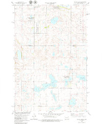
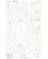
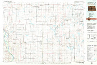
(14)- 1971 Map of New Rockford, 1974 Print
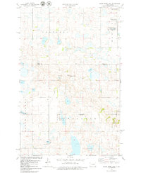
 1971 New Rockford1974 Print · USGSCentral North Dakota was a landscape of wildlife refuges and rail-linked agricultural towns in the early seventies. Genealogists and local historians can trace the development of the Fort Totten Indian Reservation and locate old railway points like Maddock, Hamal, and Kloten.
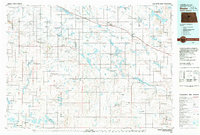
 - 1978 Map of Wagon Wheel Hill, 1979 Print
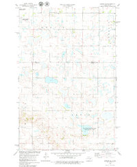
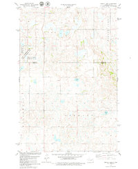
 1978 Wagon Wheel Hill1979 Print · USGSKidder and Wells Counties are shown in the late seventies as a land of prairie potholes and conservation efforts. Researchers can locate a quiet Cem, trace the shoreline of Swan Lake, or find historic water sources like the Flowing Well.
 - 1978 Map of Bowdon SE, 1979 Print
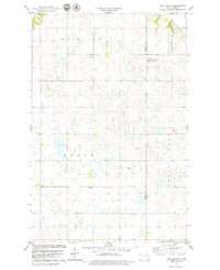
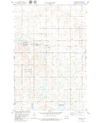
 1978 Bowdon SE1979 Print · USGSThe prairie wetlands of central North Dakota are shown in the late 1970s across the Wells Co Kidder Co line. Researchers can locate township divisions like Berlin and Rexin, as well as the Seventh-day Adventist Ch and rural cemeteries.
 - 1978 Map of Pony Gulch, 1979 Print
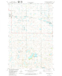
 1978 Pony Gulch1979 Print · USGSSheridan and Wells Counties appear here in the late seventies, showing a landscape shaped by prairie potholes and the civil township system. Researchers can locate the central Townhall and trace the borders of Fairview and Boone near Crystal Lake.
 - 1978 Map of Goodrich East, 1979 Print
 1978 Goodrich East1979 Print · USGSSheridan County in the late seventies is a landscape of prairie potholes and small-town rail commerce. Trace the path of the Burlington Northern railroad through Goodrich or locate conservation sites like the National Waterfowl Production Area.
 - 1978 Map of Willow Lake, 1979 Print
 1978 Willow Lake1979 Print · USGSKidder and Wells Counties in the late seventies show a prairie landscape shaped by glacial basins and conservation. Genealogists and researchers can trace township lines in North Merkel and Stewart or locate the site of Townhall near Silver Lake.
 - 1978 Map of Senior Lake, 1979 Print
 1978 Senior Lake1979 Print · USGSKidder and Wells counties are shown here in the late seventies, a period defined by sprawling waterfowl conservation and prairie wetlands. Local researchers can locate the regional Townhall or trace the boundaries of the Karl T Frederick State Game Management Area near Silver Lake.
 - 1978 Map of Hurdsfield, 1979 Print
 1978 Hurdsfield1979 Print · USGSNorth Dakota's prairie landscape in the late seventies centers on the rail-aligned town of Hurdsfield. Genealogists and historians can trace local landmarks like Pleasant Hill Cem and numerous National Waterfowl Production Areas.
 - 1978 Map of Chaseley, 1979 Print
 1978 Chaseley1979 Print · USGSThe prairie landscape of Wells County is captured here in the late seventies, showing the vital rail-and-pond geography of the region. Researchers can trace family ties at Chaseley Cem and locate rural holdings near Silver Lake or along the Burlington Northern line.
 - 1978 Map of Woodhouse Lake, 1979 Print
 1978 Woodhouse Lake1979 Print · USGSFour North Dakota counties meet in this late 1970s landscape of prairie potholes and conservation lands. Genealogists and local historians can trace township boundaries in Mauch and Hazel Grove or locate the Karl T Frederick State Game Management Area.
 - 1978 Map of Sykeston SW, 1979 Print
 1978 Sykeston SW1979 Print · USGSNorth Dakota's prairie pothole region comes to life in this late-seventies survey of the tri-county border lands. Researchers can trace rural life through landmarks like Townhall, New Home Ch, and the preserved wetlands of the National Waterfowl Production Area.
 - 1978 Map of Hawks Nest, 1979 Print
 1978 Hawks Nest1979 Print · USGSIn the late seventies, this portion of Stutsman County remained a quiet agricultural landscape dominated by glacial prairie potholes. Genealogists and local historians can locate the Lunde Ch and Cem, as well as the community Townhall and family landmarks like Hawks Nest.
 - 1979 Map of McClusky, 1980 Print
 1979 McClusky1980 Print · USGSSheridan and Burleigh Counties are shown here during the late twentieth century, when the McClusky Canal and the Burlington Northern railroad shaped the rural economy. Researchers can locate historic town centers like Pickardville and Arena alongside numerous game management areas and local landmarks like Haystack Butte.
 - 1979 Map of Drake, 1980 Print
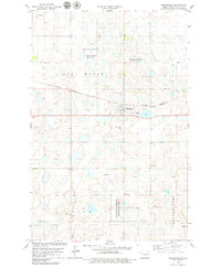
 1979 Drake1980 Print · USGSCentral North Dakota in the late seventies reveals a landscape of prairie potholes and developing water infrastructure. Trace the rail-fed growth of Drake and Anamoose or locate rural landmarks like the McClusky Canal and Lincoln Valley.
End of results
Showing maps 1-14 of 14
Top cities of Wells County
- Harvey historical maps
- Fessenden historical maps
- Sykeston historical maps
- Bowdon historical maps
- Hurdsfield historical maps
- Bremen historical maps
See more
Frequently asked questions
- What are the different types of historical maps available for Wells County?
- What is the oldest map of Wells County?
- Where can I purchase historical maps of Wells County for my home or office?
- Where can I download high-res historical maps of Wells County?
- Are there historical topographic maps available for Wells County?
- Is there historical aerial imagery available for Wells County?
- Where are historical maps of Wells County sourced from?