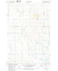
1978 Map of Hawks Nest
USGS Topo · Published 1979About this map
Hawks Nest rises as a prominent landmark in the center of this 1970s landscape where the borders of Stutsman, Wells, and Foster Counties converge. The terrain is defined by a dense network of prairie potholes and wetlands, much of which is conserved within the National Waterfowl Production Area. This era shows a sparsely populated agricultural region, anchored by local centers like the Townhall and the Lunde Ch, which sits adjacent to a Cem in the southern portion of the quadrangle. Drainage is primarily managed through the winding course of Little Pipestem Creek in the northwest. Human activity is evidenced by industrial and agricultural markers including a Gravel Pit and a large Feedlot, reflecting the land's utility in the late twentieth century. Modern infrastructure is represented by Radio Towers positioned atop the higher elevations of the Hawks Nest hills.
Find a feature on this map
15 named features on this map. Tap any name to fly to it.
Don’t see what you’re looking for? This feature index may not catch every label — zoom into the map to look around manually.
Map Details
Editions of this 1978 Hawks Nest Map
This is the sole edition of this map. No revisions or reprints were ever made.
Other maps of this area

1948 · Carrington
USGS Topo · 1:62,500

1950 · Carrington SW
USGS Topo · 1:24,000

1950 · Carrington West
USGS Topo · 1:24,000

1951 · Dover
USGS Topo · 1:24,000

1951 · Sykeston
USGS Topo · 1:24,000

1952 · New Rockford
USGS Topo · 1:250,000

1956 · New Rockford
USGS Topo · 1:250,000

1958 · Goldwin
USGS Topo · 1:24,000

1971 · New Rockford
USGS Topo · 1:250,000

1972 · Woodworth
USGS Topo · 1:24,000