1940s Maps of Fessenden, North Dakota
Explore 3 historic maps of Fessenden from the 1940s. These maps offer a rare glimpse into what life looked like during the 1940s — showing old roads, neighborhoods, homes, and landmarks that have changed or disappeared over time.
Whether you're researching your family's past, planning a metal detecting trip, or studying how Fessenden's landscape evolved across the 1940s, these high-resolution maps are a powerful tool for exploring the history of this region.
- Focus on a specific era: All maps on this page are from the 1940s, giving you a focused view of this time period.
- See what’s changed: Compare century-old streets, trails, and buildings to today's modern landscape using overlays and satellite layers.
- Research with precision: Use these maps for genealogy, historical research, land use analysis, or educational projects.
- View, download, or print: Maps are fully viewable online in high resolution, and can be downloaded or printed for your own records.
Start exploring Fessenden's history through authentic maps from the 1940s. This is your window into the past.
Fessenden, ND maps
(3)- 1948 Map of Fessenden
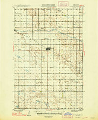 1948 Fessenden1948 Print · USGSWells County was a landscape of township schools and prairie settlements during the 1940s. Genealogists can trace family landmarks like Brynjulson Cem and Concordia Ch, or locate vanished schoolhouses such as Oshkosh Sch.2 unique versions available
 - 1949 Map of Fessenden East
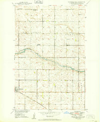 1949 Fessenden East1949 Print · USGSWells County, North Dakota, is documented here in the late 1940s as a region of dispersed prairie farmsteads and rural townships. Genealogists can locate family landmarks like Bloomington School No 3, Concordia Cem, and the tracks of the Minneapolis St Paul and Sault Ste Marie.2 unique versions available
 - 1949 Map of Fessenden West
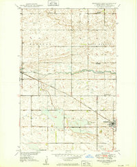 1949 Fessenden West1949 Print · USGSWells County at mid-century reveals a rural landscape defined by the iron rails and prairie townships of central North Dakota. Researchers can locate family landmarks like the German Baptist Cem, Mohr Landing field, and early local schools like Bloomington School No 4.2 unique versions available
End of results
Showing maps 1-3 of 3
Top cities near Fessenden
- Sykeston historical maps
- Bowdon historical maps
- Heimdal historical maps
- Manfred historical maps
- Cathay historical maps
- Chaseley historical maps
See more
Frequently asked questions
- What are the different types of historical maps available for Fessenden?
- What is the oldest map of Fessenden?
- Where can I purchase historical maps of Fessenden for my home or office?
- Where can I download high-res historical maps of Fessenden?
- Are there historical topographic maps available for Fessenden?
- Is there historical aerial imagery available for Fessenden?
- Where are historical maps of Fessenden sourced from?