
1949 Map of Fessenden West
USGS Topo · Published 1949About this map
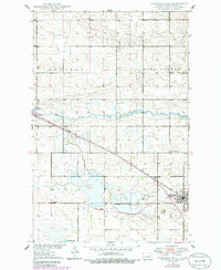
The county seat of Fessenden anchors the southeastern corner of this Wells County survey, which was compiled as part of the Department of the Interior's Missouri River Basin development program. The landscape is defined by the winding course of the James River and the steady tracks of the Minneapolis St Paul and Sault Ste Marie railroad, which connects the community to the smaller settlement of Manfred.
Find a feature on this map
19 named features on this map. Tap any name to fly to it.
Don’t see what you’re looking for? This feature index may not catch every label — zoom into the map to look around manually.
Map Details
Editions of this 1949 Fessenden West Map
2 editions found
Other maps of this area

1941 · Selz
USGS Topo · 1:62,500

1943 · Maddock
USGS Topo · 1:62,500

1945 · Maddock
USGS Topo · 1:62,500

1945 · Manfred
USGS Topo · 1:62,500

1948 · Fessenden
USGS Topo · 1:62,500

1948 · Manfred
USGS Topo · 1:62,500

1949 · Fessenden SW
USGS Topo · 1:24,000

1949 · Fessenden East
USGS Topo · 1:24,000

1949 · Emrick
USGS Topo · 1:24,000

1950 · Manfred SE
USGS Topo · 1:24,000