1900s (20th Century) Maps of Springbrook, North Dakota
Explore 6 historic maps of Springbrook from the 1900s (20th Century). These maps offer a rare glimpse into what life looked like during the 1900s — showing old roads, neighborhoods, homes, and landmarks that have changed or disappeared over time.
Whether you're researching your family's past, planning a metal detecting trip, or studying how Springbrook's landscape evolved across the 1900s, these high-resolution maps are a powerful tool for exploring the history of this region.
- Focus on a specific era: All maps on this page are from the 1900s, giving you a focused view of this time period.
- See what’s changed: Compare century-old streets, trails, and buildings to today's modern landscape using overlays and satellite layers.
- Research with precision: Use these maps for genealogy, historical research, land use analysis, or educational projects.
- View, download, or print: Maps are fully viewable online in high resolution, and can be downloaded or printed for your own records.
Start exploring Springbrook's history through authentic maps from the 1900s. This is your window into the past.
Springbrook, ND maps
(6)- 1911 Map of Ray
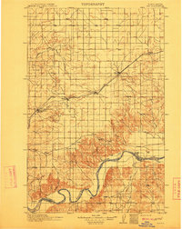 1911 Ray1911 Print · USGSNorthwest North Dakota at the height of the homesteading era reveals a landscape defined by the iron rails and the wide Missouri. Genealogists and researchers can trace the early rail stops like Wheelock and Epping or locate river landmarks such as Nesson Ferry and Banks.2 unique versions available
 - 1953 Map of Williston, 1968 Print
 1953 Williston1968 Print · USGSThe North Dakota high plains meet the waters of Sakakawea Lake in this mid-century survey of the northern borderlands. Trace the rail-and-ranch economy through sites like Anderson Sky Ranch, Sevenmile Corner, and the strip mines near Columbus.2 unique versions available
 - 1957 Map of Williston
 1957 Williston1957 Print · USGSNorthwestern North Dakota is shown here during the mid-fifties, dominated by the sweeping plains and the Missouri River valley. Genealogists and local historians can trace the paths of the Great Northern railroad through Williston, Tioga, and Ray, or locate early industry like the coal strip mines near Lignite.
 - 1978 Map of Spring Brook, 1979 Print
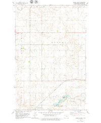 1978 Spring Brook1979 Print · USGSWilliams County in the late seventies is captured here as a landscape of prairie water systems and rail infrastructure. Researchers can trace the Spring Brook settlement and local landmarks like the Upper Missouri Bible Camp, Epping Dam, and the Cem.
 - 1979 Map of Stockyard Creek
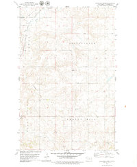 1979 Stockyard Creek1979 Print · USGSWestern North Dakota’s high plains and deep coulees are captured here in the late seventies. Genealogists and local historians can locate the Townhall, trace the Burlington Northern rail line, and map the drainage of Stockyard Creek.
 - 1983 Map of Williston, 1984 Print
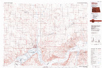 1983 Williston1984 Print · USGSWilliston and the Missouri River basin are captured here in the early eighties as the regional landscape transitioned into a modern energy and agricultural hub. Researchers can trace the Burlington Northern line through prairie towns like Epping and Wheelock, or explore the riparian geography of Lake Sakakawea.
End of results
Showing maps 1-6 of 6
Top cities near Springbrook
Top neighborhoods of Springbrook
Frequently asked questions
- What are the different types of historical maps available for Springbrook?
- What is the oldest map of Springbrook?
- Where can I purchase historical maps of Springbrook for my home or office?
- Where can I download high-res historical maps of Springbrook?
- Are there historical topographic maps available for Springbrook?
- Is there historical aerial imagery available for Springbrook?
- Where are historical maps of Springbrook sourced from?