1960s Maps of Troy Township, Ohio
Explore 5 historic maps of Troy Township from the 1960s. These maps offer a rare glimpse into what life looked like during the 1960s — showing old roads, neighborhoods, homes, and landmarks that have changed or disappeared over time.
Whether you're researching your family's past, planning a metal detecting trip, or studying how Troy Township's landscape evolved across the 1960s, these high-resolution maps are a powerful tool for exploring the history of this region.
- Focus on a specific era: All maps on this page are from the 1960s, giving you a focused view of this time period.
- See what’s changed: Compare century-old streets, trails, and buildings to today's modern landscape using overlays and satellite layers.
- Research with precision: Use these maps for genealogy, historical research, land use analysis, or educational projects.
- View, download, or print: Maps are fully viewable online in high resolution, and can be downloaded or printed for your own records.
Start exploring Troy Township's history through authentic maps from the 1960s. This is your window into the past.
Troy Township, OH maps
(5)- 1960 Map of Coolville, 1961 Print
 1960 Coolville1961 Print · USGSThe Hocking River valley and Wayne National Forest are captured here in the early sixties, showing a landscape of ridge-top farms and timber. Genealogists can locate family landmarks such as Stewart Cem, Bethel Ch, and the Olive-Orange Township Sch.4 unique versions available
 - 1961 Map of Clarksburg
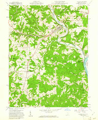
 1961 Clarksburg1961 Print · USGSThe mid-century industrial and river landscapes of West Virginia and Ohio are detailed here, centered on the Ohio River. Researchers can trace the Baltimore and Ohio rail lines connecting towns like Parkersburg, Clarksburg, and Monongah.
 - 1961 Map of Lubeck, 1963 Print
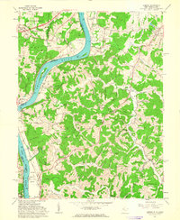 1961 Lubeck1963 Print · USGSThe West Virginia-Ohio border along the Ohio River is captured here in the early sixties, showing the vital river-and-rail infrastructure of the era. Researchers can trace family history through dozens of rural burial sites like Hickenbottom Cem or explore riverside landmarks such as Mustapha Island.4 unique versions available
 - 1961 Map of Little Hocking, 1963 Print
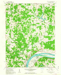 1961 Little Hocking1963 Print · USGSThe Ohio River valley south of Parkersburg comes to life in the early sixties, showing the vital river-and-rail corridor at Little Hocking. Family historians can trace rural roots through Quaker Cem and Neal Cem, or locate landmarks like the Covered Bridge.4 unique versions available
 - 1961 Map of Cutler, 1963 Print
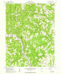 1961 Cutler1963 Print · USGSSoutheast Ohio in the early sixties reveals a landscape of winding river valleys and ridge-top farms within the Wayne National Forest. Genealogists can trace family names through dozens of sites like Beebe Cem and Crippen Cem, or locate landmarks such as the Cutler Sch and Haga Ch.3 unique versions available
End of results
Showing maps 1-5 of 5
Top cities near Troy Township
- Parkersburg historical maps
- Belpre historical maps
- Blennerhassett historical maps
- Dunham historical maps
- Barlow historical maps
- Chester historical maps
See more
Top neighborhoods of Troy Township
- Hockingport historical maps
- Torch historical maps
- Ireland historical maps
- Youba historical maps
- Coolville historical maps
Frequently asked questions
- What are the different types of historical maps available for Troy Township?
- What is the oldest map of Troy Township?
- Where can I purchase historical maps of Troy Township for my home or office?
- Where can I download high-res historical maps of Troy Township?
- Are there historical topographic maps available for Troy Township?
- Is there historical aerial imagery available for Troy Township?
- Where are historical maps of Troy Township sourced from?