1920s Maps of Troy Township, Ohio
Explore 2 historic maps of Troy Township from the 1920s. These maps offer a rare glimpse into what life looked like during the 1920s — showing old roads, neighborhoods, homes, and landmarks that have changed or disappeared over time.
Whether you're researching your family's past, planning a metal detecting trip, or studying how Troy Township's landscape evolved across the 1920s, these high-resolution maps are a powerful tool for exploring the history of this region.
- Focus on a specific era: All maps on this page are from the 1920s, giving you a focused view of this time period.
- See what’s changed: Compare century-old streets, trails, and buildings to today's modern landscape using overlays and satellite layers.
- Research with precision: Use these maps for genealogy, historical research, land use analysis, or educational projects.
- View, download, or print: Maps are fully viewable online in high resolution, and can be downloaded or printed for your own records.
Start exploring Troy Township's history through authentic maps from the 1920s. This is your window into the past.
Troy Township, OH maps
(2)- 1924 Map of Belleville, 1954 Print
 1924 Belleville1954 Print · USGSWood County’s riverfront settlements and rural school districts are captured here in the mid-twenties during the height of the rail era. Genealogists can locate long-lost family landmarks like Harris Ferry, Meldahl, and dozens of rural schoolhouses including Leafy Glen School.
 - 1926 Map of Belleville
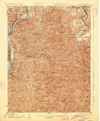 1926 Belleville1926 Print · USGSThe Ohio River valley and its rugged Wood County hinterlands come into focus in the mid-twenties. Genealogists and historians can locate dozens of rural schools and churches like Leafy Glen School, Torch PO, and Serepta Church along the winding runs.2 unique versions available
End of results
Showing maps 1-2 of 2
Top cities near Troy Township
- Parkersburg historical maps
- Belpre historical maps
- Blennerhassett historical maps
- Dunham historical maps
- Barlow historical maps
- Chester historical maps
See more
Top neighborhoods of Troy Township
- Hockingport historical maps
- Torch historical maps
- Ireland historical maps
- Youba historical maps
- Coolville historical maps
Frequently asked questions
- What are the different types of historical maps available for Troy Township?
- What is the oldest map of Troy Township?
- Where can I purchase historical maps of Troy Township for my home or office?
- Where can I download high-res historical maps of Troy Township?
- Are there historical topographic maps available for Troy Township?
- Is there historical aerial imagery available for Troy Township?
- Where are historical maps of Troy Township sourced from?