1900-1909 Maps of Franklin County, Ohio
Explore 5 historic maps of Franklin County from 1900-1909. These maps offer a rare glimpse into what life looked like during the 1900s — showing old roads, neighborhoods, homes, and landmarks that have changed or disappeared over time.
Whether you're researching your family's past, planning a metal detecting trip, or studying how Franklin County's landscape evolved across the 1900s, these high-resolution maps are a powerful tool for exploring the history of this region.
- Focus on a specific era: All maps on this page are from the 1900s, giving you a focused view of this time period.
- See what’s changed: Compare century-old streets, trails, and buildings to today's modern landscape using overlays and satellite layers.
- Research with precision: Use these maps for genealogy, historical research, land use analysis, or educational projects.
- View, download, or print: Maps are fully viewable online in high resolution, and can be downloaded or printed for your own records.
Start exploring Franklin County's history through authentic maps from the 1900s. This is your window into the past.
Franklin County, OH maps
(5)- 1901 Map of Dublin, 1955 Print
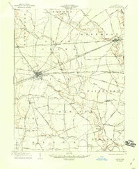
 1901 Dublin1955 Print · USGSCentral Ohio at the turn of the century reveals a landscape of independent agricultural villages and busy rail corridors long before the suburban expansion. Trace early property and settlement patterns in Dublin, Worthington, and Hilliard, and locate vanished rail stops along the Pennsylvania System and the Columbus Delaware and Marion Electric Ry.
 - 1902 Map of Westerville, 1958 Print
 1902 Westerville1958 Print · USGSFranklin and Delaware counties at the turn of the century show a landscape transitioning from rural mill seats to rail-connected suburbs. Genealogists can trace family footprints through historic settlements like Westerville, Gahanna, and the trolley-linked Central College.
 - 1903 Map of Dublin, 1939 Print
 1903 Dublin1939 Print · USGSCentral Ohio at the turn of the century is captured here as a landscape of river valleys and emerging railroad towns. Genealogists can trace early homesteads and routes between established centers like Worthington and smaller rural stops such as Amlin and Powell.2 unique versions available
 - 1904 Map of Westerville, 1941 Print
 1904 Westerville1941 Print · USGSCentral Ohio at the turn of the century shows a landscape transitioning from rural crossroads to early suburban rail hubs. Genealogists and local historians can trace the paths of the Columbus and Newark Electric R.R. and locate vanished local points like Africa, Central College, and Unhook.2 unique versions available
 - 1907 Map of London, 1940 Print
 1907 London1940 Print · USGSMadison County at the turn of the century shows a landscape transitioning through the height of the electric railway era. Genealogists can trace the rural schoolhouses like Dunn School and Glade School or locate family sites near Lilly Chapel and Lafayette.2 unique versions available
End of results
Showing maps 1-5 of 5
Top cities of Franklin County
- Columbus historical maps
- Upper Arlington historical maps
- Whitehall historical maps
- Bexley historical maps
- Grandview Heights historical maps
- Obetz historical maps
See more
Frequently asked questions
- What are the different types of historical maps available for Franklin County?
- What is the oldest map of Franklin County?
- Where can I purchase historical maps of Franklin County for my home or office?
- Where can I download high-res historical maps of Franklin County?
- Are there historical topographic maps available for Franklin County?
- Is there historical aerial imagery available for Franklin County?
- Where are historical maps of Franklin County sourced from?