1920s Maps of Franklin County, Ohio
Explore 3 historic maps of Franklin County from the 1920s. These maps offer a rare glimpse into what life looked like during the 1920s — showing old roads, neighborhoods, homes, and landmarks that have changed or disappeared over time.
Whether you're researching your family's past, planning a metal detecting trip, or studying how Franklin County's landscape evolved across the 1920s, these high-resolution maps are a powerful tool for exploring the history of this region.
- Focus on a specific era: All maps on this page are from the 1920s, giving you a focused view of this time period.
- See what’s changed: Compare century-old streets, trails, and buildings to today's modern landscape using overlays and satellite layers.
- Research with precision: Use these maps for genealogy, historical research, land use analysis, or educational projects.
- View, download, or print: Maps are fully viewable online in high resolution, and can be downloaded or printed for your own records.
Start exploring Franklin County's history through authentic maps from the 1920s. This is your window into the past.
Franklin County, OH maps
(3)- 1923 Map of West Columbus, 1955 Print
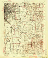
 1923 West Columbus1955 Print · USGSFranklin County in the early twenties shows the growing western edge of Columbus and its surrounding rural townships. Genealogists and historians can trace the paths of the National Road and find landmarks like Camp Chase, Urbancrest, and Pisgah School.
 - 1925 Map of East Columbus, 1940 Print
 1925 East Columbus1940 Print · USGSGreater Columbus and its eastern suburbs were rapidly expanding in the 1920s as industry and transit lines bridged the gap between city and farm. Genealogists and historians can trace the paths of the ABANDONED CANAL, the legacy of NORTON FIELD, and old village centers like Canal Winchester and Lithopolis.3 unique versions available
 - 1925 Map of West Columbus, 1946 Print
 1925 West Columbus1946 Print · USGSFranklin and Pickaway counties are shown here in the mid-twenties, when the growing state capital met a landscape of electric railways and rural schoolhouses. Researchers can trace the National Road and locate sites like the Pisgah School, Mt Calvary Cemetery, and the State Hospital.
End of results
Showing maps 1-3 of 3
Top cities of Franklin County
- Columbus historical maps
- Upper Arlington historical maps
- Whitehall historical maps
- Bexley historical maps
- Grandview Heights historical maps
- Obetz historical maps
See more
Frequently asked questions
- What are the different types of historical maps available for Franklin County?
- What is the oldest map of Franklin County?
- Where can I purchase historical maps of Franklin County for my home or office?
- Where can I download high-res historical maps of Franklin County?
- Are there historical topographic maps available for Franklin County?
- Is there historical aerial imagery available for Franklin County?
- Where are historical maps of Franklin County sourced from?