1990s Maps of Franklin County, Ohio
Explore 5 historic maps of Franklin County from the 1990s. These maps offer a rare glimpse into what life looked like during the 1990s — showing old roads, neighborhoods, homes, and landmarks that have changed or disappeared over time.
Whether you're researching your family's past, planning a metal detecting trip, or studying how Franklin County's landscape evolved across the 1990s, these high-resolution maps are a powerful tool for exploring the history of this region.
- Focus on a specific era: All maps on this page are from the 1990s, giving you a focused view of this time period.
- See what’s changed: Compare century-old streets, trails, and buildings to today's modern landscape using overlays and satellite layers.
- Research with precision: Use these maps for genealogy, historical research, land use analysis, or educational projects.
- View, download, or print: Maps are fully viewable online in high resolution, and can be downloaded or printed for your own records.
Start exploring Franklin County's history through authentic maps from the 1990s. This is your window into the past.
Franklin County, OH maps
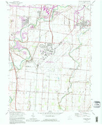
(5)- 1992 Map of Bellefontaine
 1992 Bellefontaine1992 Print · USGSWest-central Ohio in the early nineties reveals a blend of high-plateau geography and growing suburban corridors near the state capital. Genealogists can trace family connections to landmarks like Mount Tabor Church, Oak Grove Cemetery, and the high ground of Campbell Hill.
 - 1992 Map of Lockbourne, 1995 Print
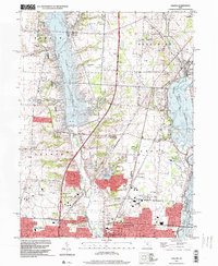
 1992 Lockbourne1995 Print · USGSThe Scioto River valley south of Columbus appears here during the early nineties, showing the intersection of military history and rural tradition. Genealogists can trace family landmarks like Fernwood Cem, St Vincents Ch, and the remnants of the Ohio Canal.
 - 1995 Map of Northwest Columbus, 1999 Print
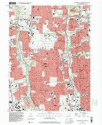 1995 Northwest Columbus1999 Print · USGSNorth Columbus and its river corridors show extensive suburban development in the mid-nineties. Researchers can locate long-standing institutions like the State School for the Deaf, the RR Museum, and the historic Union Cemetery.2 unique versions available
 - 1995 Map of Northeast Columbus, 1999 Print
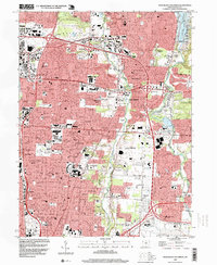 1995 Northeast Columbus1999 Print · USGSThe suburbs of northeast Franklin County undergo rapid expansion in the 1990s between the Alum and Big Walnut Creek valleys. Genealogists and local historians can trace legacy sites like Otterbein Cem, Central College, and the historical footprint of Parks Mills.
 - 1995 Map of Galena, 1999 Print
 1995 Galena1999 Print · USGSCentral Ohio at the close of the century shows the suburban growth of Westerville and Columbus alongside major reservoirs. Trace the history of Africa, Otterbein College, and the sprawling Alum Creek State Park.
End of results
Showing maps 1-5 of 5
Top cities of Franklin County
- Columbus historical maps
- Upper Arlington historical maps
- Whitehall historical maps
- Bexley historical maps
- Grandview Heights historical maps
- Obetz historical maps
See more
Frequently asked questions
- What are the different types of historical maps available for Franklin County?
- What is the oldest map of Franklin County?
- Where can I purchase historical maps of Franklin County for my home or office?
- Where can I download high-res historical maps of Franklin County?
- Are there historical topographic maps available for Franklin County?
- Is there historical aerial imagery available for Franklin County?
- Where are historical maps of Franklin County sourced from?