2020s Maps of Huron County, Ohio
Explore 19 historic maps of Huron County from the 2020s. These maps offer a rare glimpse into what life looked like during the 2020s — showing old roads, neighborhoods, homes, and landmarks that have changed or disappeared over time.
Whether you're researching your family's past, planning a metal detecting trip, or studying how Huron County's landscape evolved across the 2020s, these high-resolution maps are a powerful tool for exploring the history of this region.
- Focus on a specific era: All maps on this page are from the 2020s, giving you a focused view of this time period.
- See what’s changed: Compare century-old streets, trails, and buildings to today's modern landscape using overlays and satellite layers.
- Research with precision: Use these maps for genealogy, historical research, land use analysis, or educational projects.
- View, download, or print: Maps are fully viewable online in high resolution, and can be downloaded or printed for your own records.
Start exploring Huron County's history through authentic maps from the 2020s. This is your window into the past.
Huron County, OH maps
(19)- 2023 Map of New London, 2023 Print
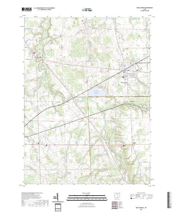 2023 New London2023 Print · USGSThis part of North Central Ohio is shown in the modern era, where traditional rural settlements and river branches converge. Local historians can trace family ties through several grounds including Fitchville Cem, Quaker Cem, and Grove Street Cem.
 - 2023 Map of Kipton, 2023 Print
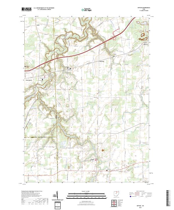 2023 Kipton2023 Print · USGSKipton and the rural townships of North Central Ohio appear here in the early twenty-first century, showing a landscape of scattered villages and family farmsteads. Genealogists can locate several historic burial sites like Harrison Cemetery and Sanders Hill Cemetery, alongside landmarks like Firelands Boy Scout Lake.
 - 2023 Map of Flat Rock, 2023 Print
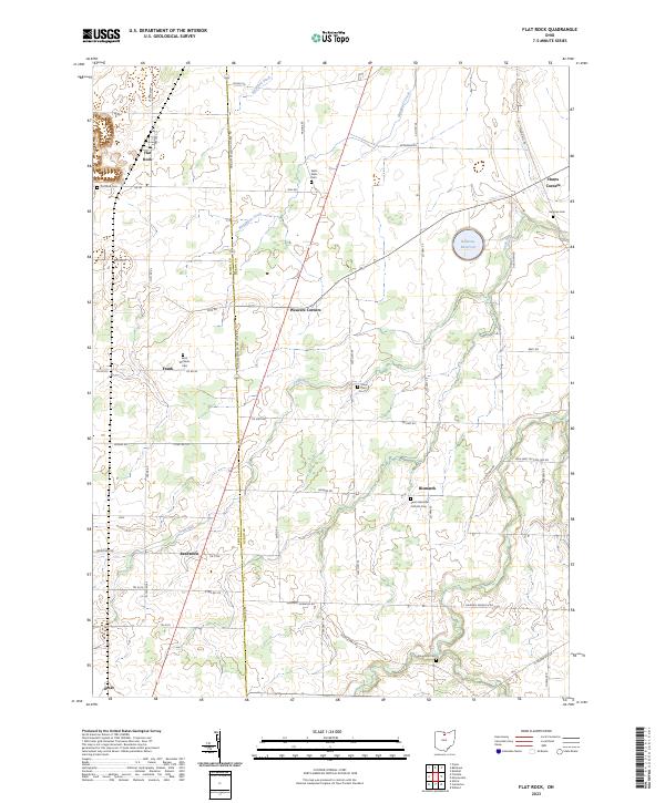 2023 Flat Rock2023 Print · USGSNorth-central Ohio farm country is meticulously detailed here in the 2020s, spanning the border of Seneca and Huron Counties. Researchers can locate several rural burial grounds and crossroads hamlets including Saint Michaels Cem, Reedtown, and Bismarck.
 - 2023 Map of Brighton, 2023 Print
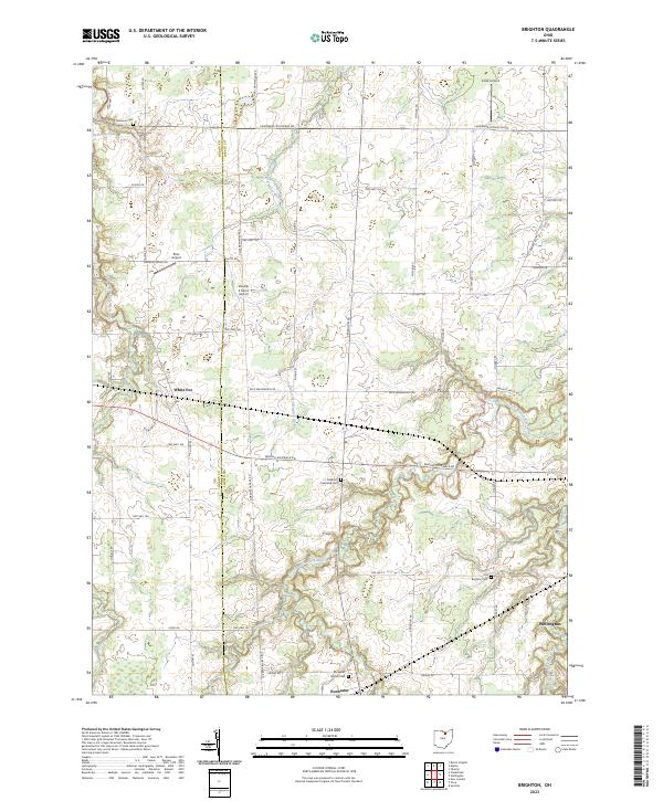 2023 Brighton2023 Print · USGSLorain and Huron counties are captured here in the 2020s, revealing a landscape of family-run airports and historic burial grounds. Genealogists can locate ancestors at Old Brighton Cem or Sherman Cem, while tracing the course of the West Branch Black River.
 - 2023 Map of Bellevue, 2023 Print
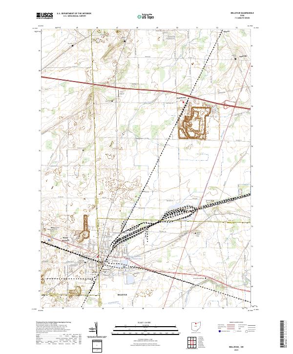 2023 Bellevue2023 Print · USGSInland from Lake Erie in the 2020s, this area of northern Ohio reveals a landscape defined by county-line crossroads and municipal reservoirs. Researchers can trace family history through a dozen rural burial grounds including Wickwire Cem and Sandhill Cem near the hamlet of Weyers.
 - 2023 Map of Monroeville, 2023 Print
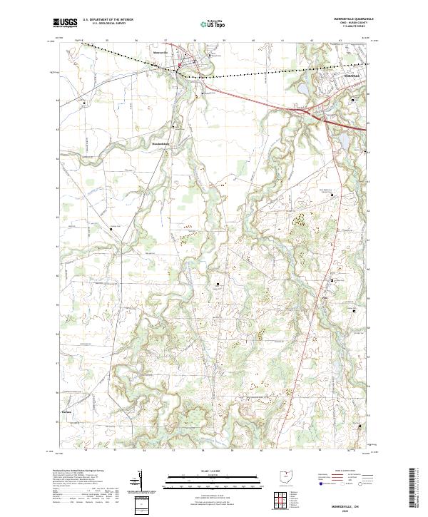 2023 Monroeville2023 Print · USGSHuron County's rural heartland is documented in the modern era, showing the persistent settlement patterns of the Firelands. Researchers can locate numerous family and church burial sites like Pontiac Cem, Hester Cem, and the uniquely named Axe Factory Cem.
 - 2023 Map of Greenwich, 2023 Print
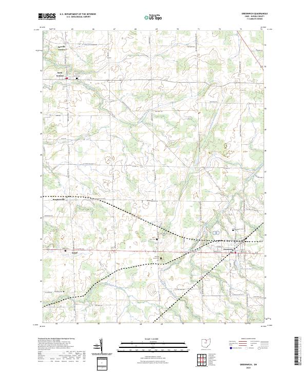 2023 Greenwich2023 Print · USGSAgricultural lands and river branches define this Huron County landscape in the 2020s. Genealogists can trace early families through Barre Farm Cem and Greenlawn Cem, or locate landmarks like Boughtonville and Greenwich Reservoir.
 - 2023 Map of Shiloh, 2023 Print
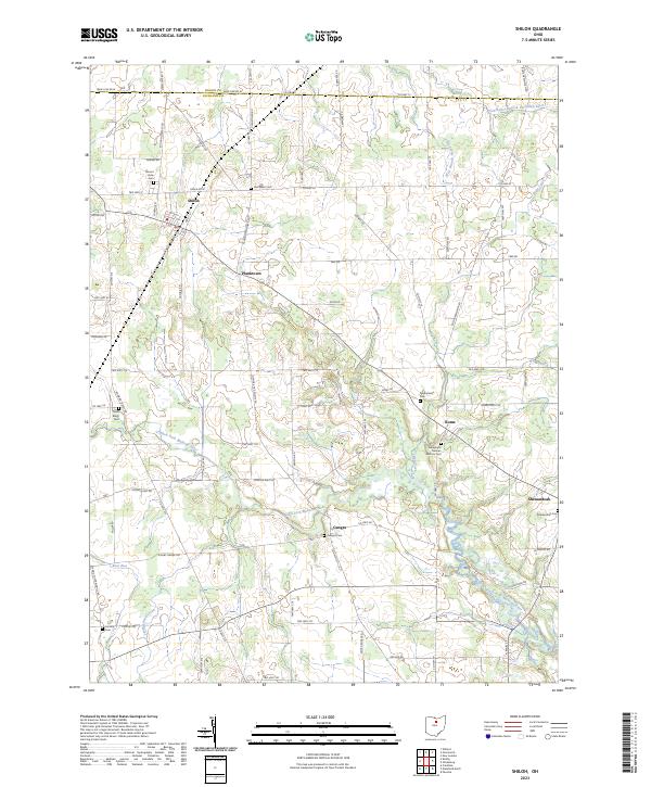 2023 Shiloh2023 Print · USGSRichland County farmland at the turn of the 21st century remains defined by its network of crossroads hamlets and small waterways. Genealogists can locate family burial sites at Mount Hope Cem, Old Salem Cem, and the Evangelical German Reform Cem.
 - 2023 Map of New Washington, 2023 Print
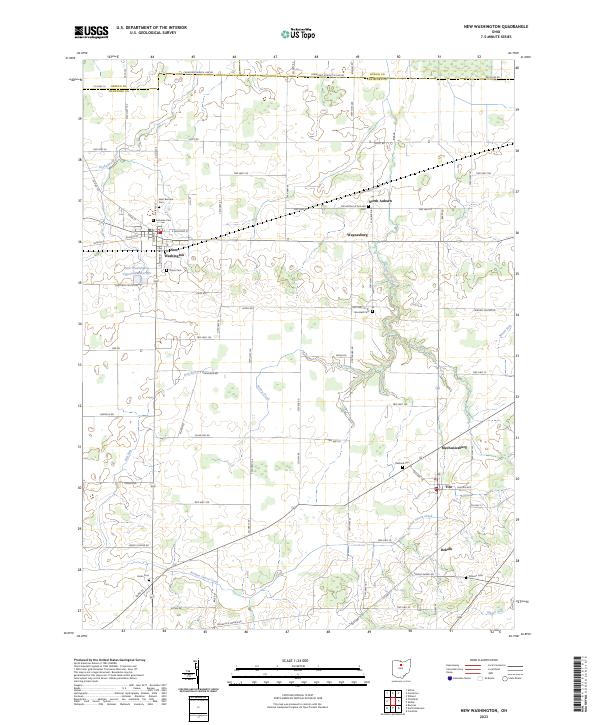 2023 New Washington2023 Print · USGSCrawford County's agricultural heartland is documented here in the early twenty-first century, centered on the village of New Washington. Genealogists can trace local history through numerous burial sites like Our Mother of Sorrows Cem and Goodwill Cem.
 - 2023 Map of Willard, 2023 Print
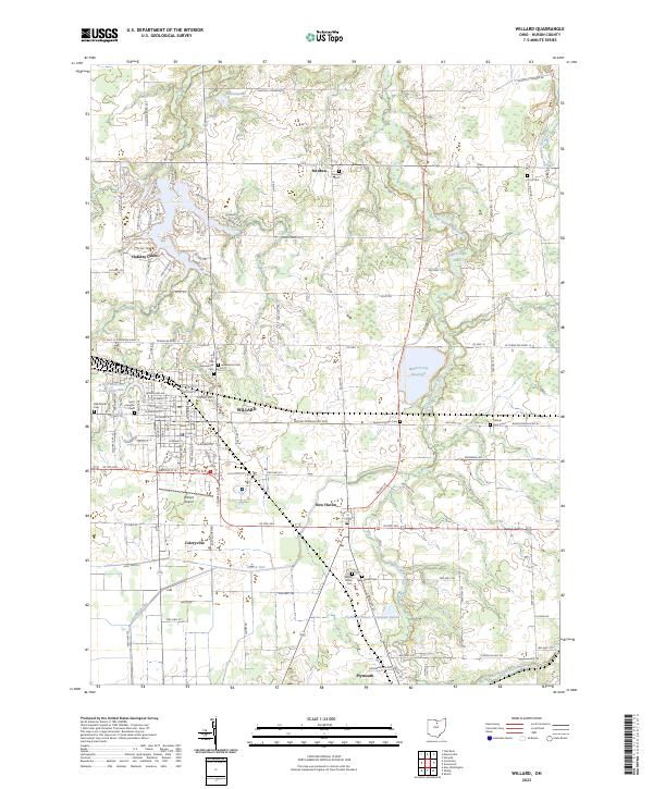 2023 Willard2023 Print · USGSHuron County's agricultural and rail heartland is captured here, centered on the hub of Willard and the surrounding muck farms. Genealogists can trace family lines through several rural burial grounds, including Old Greenwood Cem and Fullmer Farm Cem.
 - 2023 Map of Olivesburg, 2023 Print
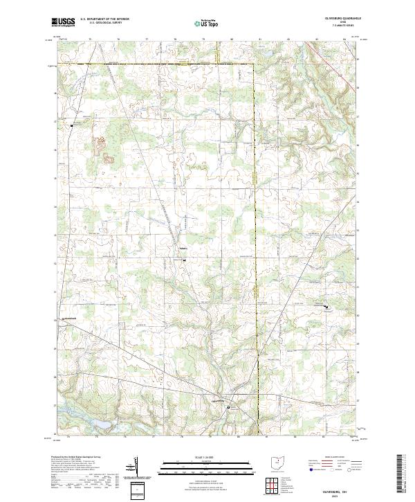 2023 Olivesburg2023 Print · USGSRichland County's rural crossroads and family homesteads are preserved in this recent survey of the Olivesburg area. Researchers can trace ancestral sites through Mount Olivet Cem, the Reformed Church, and the quiet village centers of Adario and Shenandoah.
 - 2023 Map of Nova, 2023 Print
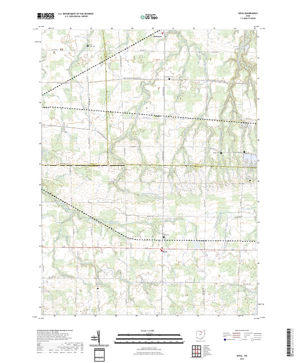 2023 Nova2023 Print · USGSAshland County and the surrounding tri-county border area are captured in the early 2020s, showing a landscape of rural crossroads and river branches. Family historians can trace local roots at German Lutheran Cem, Nova Cem, or the small settlement of Semples.
 - 2023 Map of Clarksfield, 2023 Print
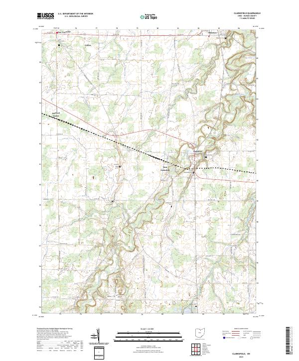 2023 Clarksfield2023 Print · USGSHuron County's rural landscape is preserved here as it appeared in the 2020s, defined by the winding Vermilion River and a deep network of township roads. Researchers can trace family history through numerous burial grounds like Five Points Cem and Collinwood Cem.
 - 2023 Map of Kimball, 2023 Print
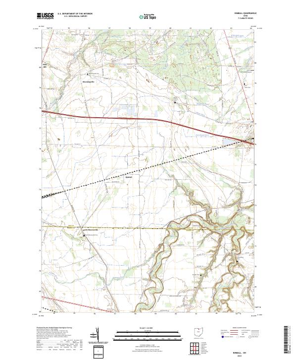 2023 Kimball2023 Print · USGSThe borderlands of Erie and Huron counties are captured here in the early twenty-first century, showing a landscape shaped by water and memory. Genealogists can locate several local burial sites like Bloomingville Cem and Ruggles Cem among the fertile bends of the Huron River.
 - 2023 Map of Berlin Heights, 2023 Print
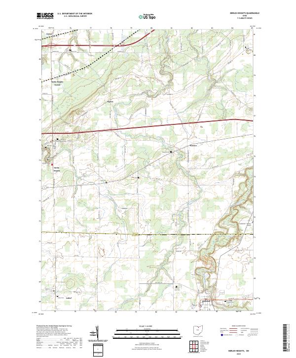 2023 Berlin Heights2023 Print · USGSNorthern Ohio's farm country and river valleys are captured here in the 2020s, spanning the border of Erie and Huron counties. Researchers can locate many local landmarks like Maple Grove Cem, Saint Mary Catholic Cem, and the village of Wakeman.
 - 2023 Map of Norwalk, 2023 Print
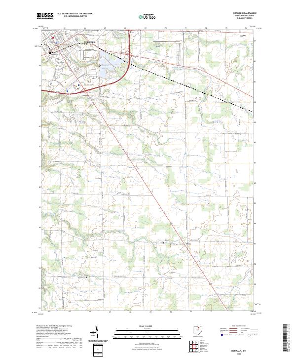 2023 Norwalk2023 Print · USGSNorwalk and the surrounding Huron County townships are documented here in the early twenty-first century, showing the evolution of this regional hub. Researchers can locate family heritage sites at Woodlawn Cem or trace the rural road networks connecting Olena and Collins.
 - 2023 Map of Milan, 2023 Print
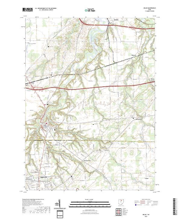 2023 Milan2023 Print · USGSNorth Central Ohio's river valleys and rural townships are captured here in the early twenty-first century. Genealogists can trace family footprints across numerous sites like Saint Marys Cem, Milan North Cem, and the historic settlement at Shinrock.
 - 2023 Map of Centerton, 2023 Print
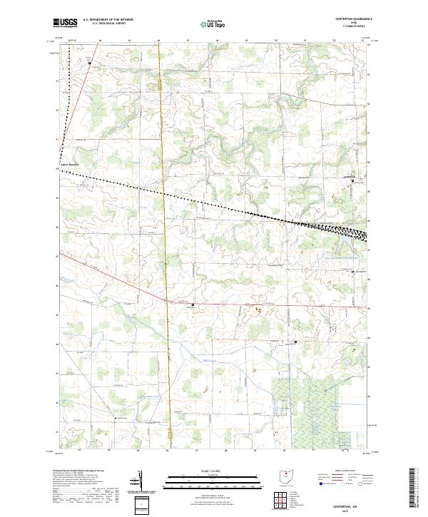 2023 Centerton2023 Print · USGSThe rural borderlands of Seneca and Huron counties are documented here in the early twenty-first century, showing a landscape of drainage ditches and family cemeteries. Researchers can locate the New Haven Marsh and trace local lineages at Centerton Cem or Bullhead Cem.
 - 2023 Map of Shelby, 2023 Print
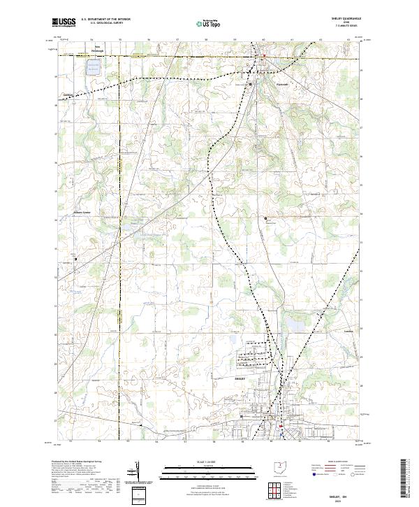 2023 Shelby2023 Print · USGSRichland and Huron counties come together in this modern survey of North Central Ohio's farming heartland. Local historians can trace the rural landscape between Shelby and Plymouth, locating legacy sites like Pioneer Rest Cem and Auburn Center.
End of results
Showing maps 1-19 of 19
Top cities of Huron County
Frequently asked questions
- What are the different types of historical maps available for Huron County?
- What is the oldest map of Huron County?
- Where can I purchase historical maps of Huron County for my home or office?
- Where can I download high-res historical maps of Huron County?
- Are there historical topographic maps available for Huron County?
- Is there historical aerial imagery available for Huron County?
- Where are historical maps of Huron County sourced from?