1900-1909 Maps of Huron County, Ohio
Explore 6 historic maps of Huron County from 1900-1909. These maps offer a rare glimpse into what life looked like during the 1900s — showing old roads, neighborhoods, homes, and landmarks that have changed or disappeared over time.
Whether you're researching your family's past, planning a metal detecting trip, or studying how Huron County's landscape evolved across the 1900s, these high-resolution maps are a powerful tool for exploring the history of this region.
- Focus on a specific era: All maps on this page are from the 1900s, giving you a focused view of this time period.
- See what’s changed: Compare century-old streets, trails, and buildings to today's modern landscape using overlays and satellite layers.
- Research with precision: Use these maps for genealogy, historical research, land use analysis, or educational projects.
- View, download, or print: Maps are fully viewable online in high resolution, and can be downloaded or printed for your own records.
Start exploring Huron County's history through authentic maps from the 1900s. This is your window into the past.
Huron County, OH maps
(6)- 1901 Map of Bellevue, 1958 Print
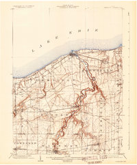
 1901 Bellevue1958 Print · USGSAcross the marshy lowlands and limestone springs of Erie and Sandusky counties at the turn of the century, a massive railroad network dominates the landscape. Genealogists can trace family footprints in Clyde and Bellevue or locate vanished rail stops at Thames and Parkertown.
 - 1903 Map of Bellevue
 1903 Bellevue1903 Print · USGSNear the dawn of the twentieth century, the junction of Erie and Sandusky counties was a bustling corridor of rail and water transport. Genealogists and historians can trace the early footprints of Bellevue and Clyde, or find specific local landmarks like the Blue Hole and the Connecticut Western Reserve Boundary Line.5 unique versions available
 - 1903 Map of Vermilion, 1932 Print
 1903 Vermilion1932 Print · USGSThe Lake Erie shoreline in the early twentieth century served as a vital transit hub where rail lines and electric cars converged on the coast. Genealogists and local historians can trace the early layouts of Vermilion, Wakeman, and Birmingham, or locate the specific placement of the Quarry and numerous creek-side homesteads.2 unique versions available
 - 1904 Map of Sandusky, 1941 Print
 1904 Sandusky1941 Print · USGSThe Lake Erie shoreline at the turn of the century shows a bustling rail-and-port economy centered on Sandusky and the Huron River. Researchers can trace early infrastructure like the Electric Line and vanished landmarks such as the State Soldiers Home.3 unique versions available
 - 1908 Map of Ashland
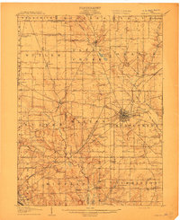 1908 Ashland1908 Print · USGSAshland and its surrounding townships are captured in 1908 at the height of the steam and electric rail era. Researchers can trace the path of the Erie Electric line or locate family-named landmarks like Anderson School and Dickey Church.4 unique versions available
 - 1908 Map of New London, 1948 Print
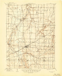 1908 New London1948 Print · USGSNorth-central Ohio at the turn of the century was a landscape of thriving rail junctions and rural school districts. Genealogists can trace family roots through numerous local landmarks like Barlams Store, Todd School, and the busy junction at New London.
End of results
Showing maps 1-6 of 6
Top cities of Huron County
Frequently asked questions
- What are the different types of historical maps available for Huron County?
- What is the oldest map of Huron County?
- Where can I purchase historical maps of Huron County for my home or office?
- Where can I download high-res historical maps of Huron County?
- Are there historical topographic maps available for Huron County?
- Is there historical aerial imagery available for Huron County?
- Where are historical maps of Huron County sourced from?