1910s Maps of Huron County, Ohio
Explore 4 historic maps of Huron County from the 1910s. These maps offer a rare glimpse into what life looked like during the 1910s — showing old roads, neighborhoods, homes, and landmarks that have changed or disappeared over time.
Whether you're researching your family's past, planning a metal detecting trip, or studying how Huron County's landscape evolved across the 1910s, these high-resolution maps are a powerful tool for exploring the history of this region.
- Focus on a specific era: All maps on this page are from the 1910s, giving you a focused view of this time period.
- See what’s changed: Compare century-old streets, trails, and buildings to today's modern landscape using overlays and satellite layers.
- Research with precision: Use these maps for genealogy, historical research, land use analysis, or educational projects.
- View, download, or print: Maps are fully viewable online in high resolution, and can be downloaded or printed for your own records.
Start exploring Huron County's history through authentic maps from the 1910s. This is your window into the past.
Huron County, OH maps
(4)- 1915 Map of Norwalk, 1936 Print
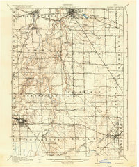 1915 Norwalk1936 Print · USGSHuron County at the peak of the steam and electric rail era shows a landscape defined by busy junction towns and rural school districts. Genealogists can trace family footprints across dozens of local districts like Egypt School or within the neighborhoods of Chicago Junction and Norwalk.2 unique versions available
 - 1915 Map of Siam, 1936 Print
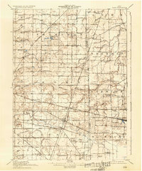 1915 Siam1936 Print · USGSThe Seneca and Huron county borderlands are shown here in the years following the turn of the century as railroads and drainage projects transformed the landscape. Researchers can trace the legacy of small communities and rural education at Siam, Attica Junction, and the Podunk School.2 unique versions available
 - 1915 Map of Bucyrus, 1940 Print
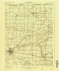 1915 Bucyrus1940 Print · USGSBucyrus and the surrounding Crawford County plains are captured here at the height of the steam-and-electric rail era. Genealogists can locate rural landmarks like the COUNTY INFIRMARY, trace family plots near Leesville, or find vanished schoolhouses like Muck School.
 - 1915 Map of Crestline, 1943 Print
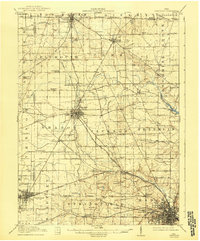 1915 Crestline1943 Print · USGSRichland and Crawford counties thrive as a vital railroad corridor in the years before the Great War. Genealogists can locate family homesteads near dozens of numbered district schools or trace the industrial pulse of Crestline, Shelby, and the Spore Mill.
End of results
Showing maps 1-4 of 4
Top cities of Huron County
Frequently asked questions
- What are the different types of historical maps available for Huron County?
- What is the oldest map of Huron County?
- Where can I purchase historical maps of Huron County for my home or office?
- Where can I download high-res historical maps of Huron County?
- Are there historical topographic maps available for Huron County?
- Is there historical aerial imagery available for Huron County?
- Where are historical maps of Huron County sourced from?