1950s Maps of Huron County, Ohio
Explore 7 historic maps of Huron County from the 1950s. These maps offer a rare glimpse into what life looked like during the 1950s — showing old roads, neighborhoods, homes, and landmarks that have changed or disappeared over time.
Whether you're researching your family's past, planning a metal detecting trip, or studying how Huron County's landscape evolved across the 1950s, these high-resolution maps are a powerful tool for exploring the history of this region.
- Focus on a specific era: All maps on this page are from the 1950s, giving you a focused view of this time period.
- See what’s changed: Compare century-old streets, trails, and buildings to today's modern landscape using overlays and satellite layers.
- Research with precision: Use these maps for genealogy, historical research, land use analysis, or educational projects.
- View, download, or print: Maps are fully viewable online in high resolution, and can be downloaded or printed for your own records.
Start exploring Huron County's history through authentic maps from the 1950s. This is your window into the past.
Huron County, OH maps
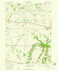
(7)- 1950 Map of Marion
 1950 Marion1950 Print · USGSCentral Ohio was a powerhouse of rail and river industry at the mid-century point, serving as a vital corridor between the Great Lakes and the Ohio River valley. Genealogists and rail historians can trace the paths of the Erie RR and Nickel Plate Road through towns like Bucyrus, Galion, and Upper Sandusky.
 - 1956 Map of Toledo, 1968 Print
 1956 Toledo1968 Print · USGSNorthwest Ohio and the Lake Erie shoreline are shown in detail during the late fifties, showcasing a landscape of heavy industry, railroads, and island communities. Genealogists and historians can trace rail networks like the Chesapeake & Ohio RR or locate landmarks such as the Erie Proving Ground and Kelleys Island.4 unique versions available
 - 1959 Map of Kimball, 1960 Print
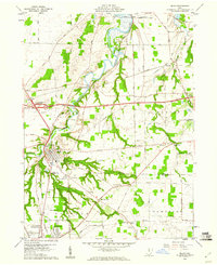
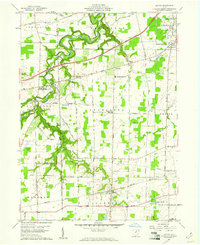
 1959 Kimball1960 Print · USGSErie County at the end of the fifties reveals a landscape shaped by military industry and the arrival of the modern turnpike. Researchers can trace family-named landmarks and old church sites like St Johns Ch, Union Corner Cem, and the rail junction at Kimball.
 - 1959 Map of Milan, 1960 Print
 1959 Milan1960 Print · USGSMilan and the surrounding Erie County townships are captured here in the late fifties, just as the turnpike began to reshape the rural landscape. Researchers can trace family history through numerous landmarks like Scotts Cem or locate old rail stops along the New York Central and New York Chicago and St Louis lines.
 - 1959 Map of Bellevue, 1960 Print
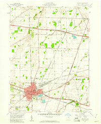 1959 Bellevue1960 Print · USGSBellevue stands at the four-county junction of Erie, Huron, Sandusky, and Seneca during the late 1950s expansion. Genealogists and local historians can trace school locations like Ridge Sch and Shumaker Sch alongside the tracks of the Pennsylvania RR.
 - 1959 Map of Berlin Heights, 1960 Print
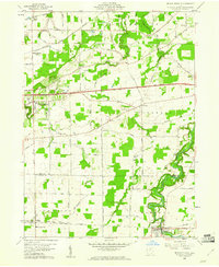 1959 Berlin Heights1960 Print · USGSNorth-central Ohio is captured in the late fifties, showing the interplay between the new Ohio Turnpike and historic farm-to-market rail lines. Local historians can trace family roots through numerous burial sites like Maple Grove Cem and Poyers Cem or locate old schoolhouse sites like Townsend Sch.2 unique versions available
 - 1959 Map of Kipton, 1961 Print
 1959 Kipton1961 Print · USGSLorain County in the late fifties shows a landscape of traditional farming and growing industry, from the quarrying district of South Amherst to the quiet village of Kipton. Genealogists and researchers can trace local landmarks like Henrietta Cem, the Nickel Plate Road, and the path of the Vermilion River.
End of results
Showing maps 1-7 of 7
Top cities of Huron County
Frequently asked questions
- What are the different types of historical maps available for Huron County?
- What is the oldest map of Huron County?
- Where can I purchase historical maps of Huron County for my home or office?
- Where can I download high-res historical maps of Huron County?
- Are there historical topographic maps available for Huron County?
- Is there historical aerial imagery available for Huron County?
- Where are historical maps of Huron County sourced from?