1900-1909 Maps of Stokes Township, Ohio
Explore 3 historic maps of Stokes Township from 1900-1909. These maps offer a rare glimpse into what life looked like during the 1900s — showing old roads, neighborhoods, homes, and landmarks that have changed or disappeared over time.
Whether you're researching your family's past, planning a metal detecting trip, or studying how Stokes Township's landscape evolved across the 1900s, these high-resolution maps are a powerful tool for exploring the history of this region.
- Focus on a specific era: All maps on this page are from the 1900s, giving you a focused view of this time period.
- See what’s changed: Compare century-old streets, trails, and buildings to today's modern landscape using overlays and satellite layers.
- Research with precision: Use these maps for genealogy, historical research, land use analysis, or educational projects.
- View, download, or print: Maps are fully viewable online in high resolution, and can be downloaded or printed for your own records.
Start exploring Stokes Township's history through authentic maps from the 1900s. This is your window into the past.
Stokes Township, OH maps
(3)- 1906 Map of Mt Sterling, 1946 Print
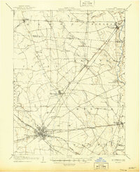 1906 Mt Sterling1946 Print · USGSCentral Ohio at the start of the twentieth century is a landscape of thriving rail hubs and rural townships. Trace the convergence of five railroads at Washington Courthouse and find family landmarks like the County Infirmary or Bloomingburg.
 - 1907 Map of London, 1940 Print
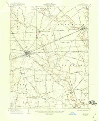 1907 London1940 Print · USGSMadison County at the turn of the century shows a landscape transitioning through the height of the electric railway era. Genealogists can trace the rural schoolhouses like Dunn School and Glade School or locate family sites near Lilly Chapel and Lafayette.2 unique versions available
 - 1907 Map of South Charleston, 1943 Print
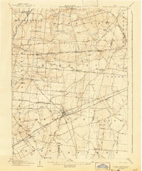 1907 South Charleston1943 Print · USGSThe Clark County countryside at the turn of the century shows a landscape dominated by rail travel and local school districts. Genealogists can locate family-named landmarks such as Yeazel School, Pancake Chapel, and the settlement of Dolly Varden.2 unique versions available
End of results
Showing maps 1-3 of 3
Top cities near Stokes Township
- Springfield historical maps
- Washington Court House historical maps
- London historical maps
- West Jefferson historical maps
- Harmony historical maps
- Jamestown historical maps
See more
Top neighborhoods of Stokes Township
Frequently asked questions
- What are the different types of historical maps available for Stokes Township?
- What is the oldest map of Stokes Township?
- Where can I purchase historical maps of Stokes Township for my home or office?
- Where can I download high-res historical maps of Stokes Township?
- Are there historical topographic maps available for Stokes Township?
- Is there historical aerial imagery available for Stokes Township?
- Where are historical maps of Stokes Township sourced from?