1900-1909 Maps of Harrisville Township, Ohio
Explore 8 historic maps of Harrisville Township from 1900-1909. These maps offer a rare glimpse into what life looked like during the 1900s — showing old roads, neighborhoods, homes, and landmarks that have changed or disappeared over time.
Whether you're researching your family's past, planning a metal detecting trip, or studying how Harrisville Township's landscape evolved across the 1900s, these high-resolution maps are a powerful tool for exploring the history of this region.
- Focus on a specific era: All maps on this page are from the 1900s, giving you a focused view of this time period.
- See what’s changed: Compare century-old streets, trails, and buildings to today's modern landscape using overlays and satellite layers.
- Research with precision: Use these maps for genealogy, historical research, land use analysis, or educational projects.
- View, download, or print: Maps are fully viewable online in high resolution, and can be downloaded or printed for your own records.
Start exploring Harrisville Township's history through authentic maps from the 1900s. This is your window into the past.
Harrisville Township, OH maps
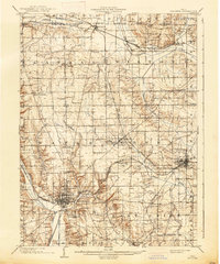
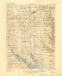
(8)- 1901 Map of Wooster, 1961 Print
 1901 Wooster1961 Print · USGSWayne County was a bustling corridor of rail and agriculture at the turn of the century, dominated by the growth of Wooster and Orrville. Researchers can trace historic institutions like Wooster University or locate the Mennonite Home and State Experiment Station.
 - 1903 Map of Wooster, 1938 Print
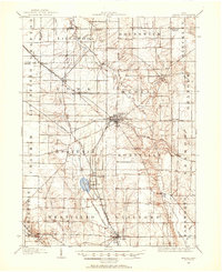
 1903 Wooster1938 Print · USGSWayne County is shown at the height of its early rail-and-river economy, with every township and rural hamlet meticulously plotted. Researchers can trace historic landmarks like Wooster University, the Mennonite Home, and the State Experiment Station as they appeared just after the turn of the century.2 unique versions available
 - 1904 Map of Medina, 1954 Print
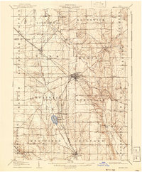
 1904 Medina1954 Print · USGSMedina and its surrounding townships are captured in the early 1900s, showing a landscape defined by the intersection of early pikes and competing steam and electric railroads. Genealogists can trace family connections in vanished stops and crossroads like River Styx, Abbeyville, and Sherman Corners.2 unique versions available
 - 1904 Map of Wellington, 1958 Print
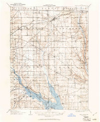
 1904 Wellington1958 Print · USGSNorth-central Ohio at the turn of the century is a network of growing rail towns and agricultural townships. Genealogists can trace family roots through settlements like Wellington, Homerville, and Lodi, while following the paths of the Wheeling and Lake Erie RR and Salt Creek.
 - 1906 Map of Medina, 1941 Print
 1906 Medina1941 Print · USGSIn Medina County at the dawn of the twentieth century, the rural landscape is a bustling network of electric rail lines and crossroads hamlets. Trace the early paths of the Cleveland Southwestern and Columbus Electric RR and find vanished rail stops like Lester or the community of River Styx.
 - 1906 Map of Wellington, 1942 Print
 1906 Wellington1942 Print · USGSNorth-central Ohio at the opening of the twentieth century was a landscape of thriving rail-junction towns and fertile creek bottoms. Genealogists and historians can trace the early footprints of Wellington, Sullivan, and Lodi as they were connected by the Baltimore and Ohio and several electric rail lines.
 - 1906 Map of West Salem, 1961 Print
 1906 West Salem1961 Print · USGSIn the early 1900s, this area of Northern Ohio was a web of small rail-side settlements and rural townships. Genealogists and historians can trace old homesteads and local landmarks like the Eight Square Ch, the village of Jeromesville, and the Mohicanville Reservoir.
 - 1908 Map of West Salem, 1946 Print
 1908 West Salem1946 Print · USGSNorth Central Ohio's rural landscape is captured here in the early twentieth century, showing the transition from early surveying reserves to a rail-connected farm economy. Researchers can locate early township centers and rail stops like Polk, Congress, and Eight Square Ch.
End of results
Showing maps 1-8 of 8
Top cities near Harrisville Township
- Brunswick historical maps
- Wooster historical maps
- Medina historical maps
- Ashland historical maps
- Orrville historical maps
- Rittman historical maps
See more
Top neighborhoods of Harrisville Township
Frequently asked questions
- What are the different types of historical maps available for Harrisville Township?
- What is the oldest map of Harrisville Township?
- Where can I purchase historical maps of Harrisville Township for my home or office?
- Where can I download high-res historical maps of Harrisville Township?
- Are there historical topographic maps available for Harrisville Township?
- Is there historical aerial imagery available for Harrisville Township?
- Where are historical maps of Harrisville Township sourced from?