1960s Maps of Mercer County, Ohio
Explore 16 historic maps of Mercer County from the 1960s. These maps offer a rare glimpse into what life looked like during the 1960s — showing old roads, neighborhoods, homes, and landmarks that have changed or disappeared over time.
Whether you're researching your family's past, planning a metal detecting trip, or studying how Mercer County's landscape evolved across the 1960s, these high-resolution maps are a powerful tool for exploring the history of this region.
- Focus on a specific era: All maps on this page are from the 1960s, giving you a focused view of this time period.
- See what’s changed: Compare century-old streets, trails, and buildings to today's modern landscape using overlays and satellite layers.
- Research with precision: Use these maps for genealogy, historical research, land use analysis, or educational projects.
- View, download, or print: Maps are fully viewable online in high resolution, and can be downloaded or printed for your own records.
Start exploring Mercer County's history through authentic maps from the 1960s. This is your window into the past.
Mercer County, OH maps
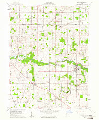
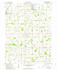
(16)- 1960 Map of Fort Recovery, 1961 Print
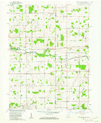
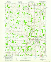 1960 Fort Recovery1961 Print · USGSThe Indiana-Ohio borderlands come into focus during the early sixties, centered on the historic village of Fort Recovery. Genealogists and historians can trace the Old Indian Treaty Road and locate numerous family burial grounds like Old Pioneer Cem and Limber Cem.2 unique versions available
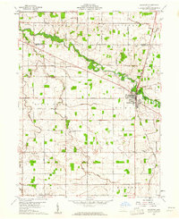
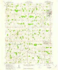
 - 1960 Map of Celina, 1961 Print
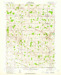
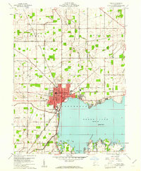 1960 Celina1961 Print · USGSMercer County life in the early sixties centers on the growing shoreline of Grand Lake and the hub of Celina. Trace historical family roots and old property lines using landmarks like North Grove Cemetery, Livingston PO, and the New York Chicago and St Louis RR.3 unique versions available
 - 1960 Map of Erastus, 1961 Print
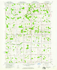
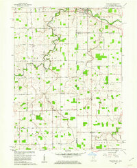
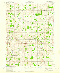 1960 Erastus1961 Print · USGSMercer County at the start of the sixties reveals a landscape of small farming hamlets and country schoolhouses. Genealogists can trace family footprints near Swamp College, Erastus, and numerous rural cemeteries like Buck Cem.2 unique versions available
 - 1960 Map of St. Marys, 1961 Print
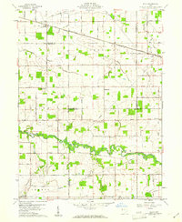
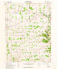
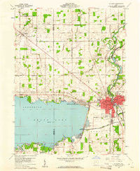 1960 St. Marys1961 Print · USGSSt. Marys and the shores of Grand Lake appear in the early sixties as a hub of water-borne history and mid-century industry. Trace the Miami and Erie Canal (Abandoned) past Forty Acre Pond and find old family sites near Neptune or Villa Nova.3 unique versions available
 - 1960 Map of Mendon, 1961 Print
 1960 Mendon1961 Print · USGSMercer and Van Wert counties are captured in the early 1960s, showing a landscape of productive farmsteads and rural crossroads. Local researchers can trace the New York Central rail line through Mendon or locate family sites like Frisinger Cem and Wesley Chapel.2 unique versions available
 - 1960 Map of Rockford, 1961 Print
 1960 Rockford1961 Print · USGSMercer and Van Wert counties are captured here at the start of the sixties, showcasing a landscape defined by the St Marys River and a busy rail junction. Genealogists can trace family names through landmarks like Riverside Cem, Fountain Chapel Cem, and the rural Bursville settlement.
 - 1960 Map of Cosmos, 1961 Print
 1960 Cosmos1961 Print · USGSThe Indiana-Ohio borderlands at the start of the sixties were a grid of productive farmland and small rural parishes. Researchers can trace ancestral sites and local landmarks like Salem, Raper Chapel, and Mt Zion Cem Ch across the state line.4 unique versions available
 - 1960 Map of Elgin, 1961 Print
 1960 Elgin1961 Print · USGSWestern Ohio farmland is captured here in the early sixties at the meeting point of four counties. Genealogists and historians can trace family-named landmarks like Fissel Lauth Cem and Hankin Cem or locate the village of Elgin along the Erie Lackawanna Railroad.
 - 1960 Map of New Corydon, 1962 Print
 1960 New Corydon1962 Print · USGSThe Indiana-Ohio borderlands come to life in this early 1960s survey of the Wabash River valley. Genealogists and researchers can trace family roots through numerous country landmarks like Jefferson Sch, Liberty Cem, and the small community of New Corydon.3 unique versions available
 - 1960 Map of Willshire, 1964 Print
 1960 Willshire1964 Print · USGSThe Indiana-Ohio borderlands come into focus in the early sixties as a patchwork of small farms and crossroads hamlets. Genealogists and historians can locate family landmarks like Tricker Cem, Blue Creek Sch, and the riverside village of Willshire.3 unique versions available
 - 1961 Map of Rossburg, 1962 Print
 1961 Rossburg1962 Print · USGSDarke and Mercer counties appear here in the early sixties, showing a landscape defined by small rail towns and the upper Stillwater River. Genealogists and local historians can trace New York Central rail stops and country landmarks like St Marys Novitiate and Zion Pilgrim Ch.2 unique versions available
 - 1961 Map of Osgood, 1963 Print
 1961 Osgood1963 Print · USGSThis western Ohio landscape at the start of the sixties reveals a countryside shaped by the historic Treaty Line and the remnants of the canal era. Genealogists can locate numerous rural burial sites like Walkup Cem and St Martins Cem near settlements like Osgood and Willowdell.3 unique versions available
 - 1961 Map of Montezuma, 1963 Print
 1961 Montezuma1963 Print · USGSMercer County's rural townships and lakeside settlements are captured here in the early sixties, showing a landscape shaped by parish life and the oil-and-gas industry. Trace local genealogy and landmarks like St Charles Seminary, Cranberry Prairie, and the St Elizabeth Cem.3 unique versions available
 - 1961 Map of North Star, 1963 Print
 1961 North Star1963 Print · USGSIn the early 1960s, this portion of Darke and Mercer counties remained a strictly agricultural landscape defined by the Greenville Treaty Line. Family researchers can trace ancestral properties near North Star or locate quiet burial grounds like Brock Cem and Holsapple Cem.2 unique versions available
 - 1961 Map of Coldwater, 1963 Print
 1961 Coldwater1963 Print · USGSMercer County in the early 1960s reveals a landscape defined by the historic Greenville Treaty Line and a network of small Catholic parish settlements. Genealogists and local historians can trace the foundations of St Henry, St Peter, and Philothea alongside the New York Central Railroad.2 unique versions available
 - 1961 Map of New Bremen, 1963 Print
 1961 New Bremen1963 Print · USGSAgricultural West-Central Ohio comes alive in the early sixties, showing the vital canal and rail corridors through the Auglaize and Mercer county border. Trace family roots through the Maria Stein Shrine or settlements like Egypt and Chickasaw.
End of results
Showing maps 1-16 of 16
Top cities of Mercer County
- Celina historical maps
- Coldwater historical maps
- St. Henry historical maps
- Fort Recovery historical maps
- Rockford historical maps
- Mendon historical maps
See more
Frequently asked questions
- What are the different types of historical maps available for Mercer County?
- What is the oldest map of Mercer County?
- Where can I purchase historical maps of Mercer County for my home or office?
- Where can I download high-res historical maps of Mercer County?
- Are there historical topographic maps available for Mercer County?
- Is there historical aerial imagery available for Mercer County?
- Where are historical maps of Mercer County sourced from?