1960s Maps of Oakwood, Ohio
Explore 2 historic maps of Oakwood from the 1960s. These maps offer a rare glimpse into what life looked like during the 1960s — showing old roads, neighborhoods, homes, and landmarks that have changed or disappeared over time.
Whether you're researching your family's past, planning a metal detecting trip, or studying how Oakwood's landscape evolved across the 1960s, these high-resolution maps are a powerful tool for exploring the history of this region.
- Focus on a specific era: All maps on this page are from the 1960s, giving you a focused view of this time period.
- See what’s changed: Compare century-old streets, trails, and buildings to today's modern landscape using overlays and satellite layers.
- Research with precision: Use these maps for genealogy, historical research, land use analysis, or educational projects.
- View, download, or print: Maps are fully viewable online in high resolution, and can be downloaded or printed for your own records.
Start exploring Oakwood's history through authentic maps from the 1960s. This is your window into the past.
Oakwood, OH maps
(2)- 1960 Map of Oakwood, 1961 Print
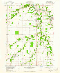 1960 Oakwood1961 Print · USGSPaulding County is seen here in the early 1960s, defined by the winding Auglaize River and small railroad towns. Genealogists can trace family names at Kingery Cem or Faught Cem and locate landmarks like Fort Brown.2 unique versions available
 - 1960 Map of Continental, 1961 Print
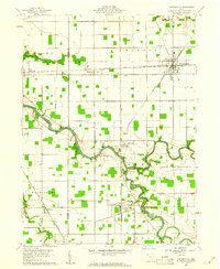 1960 Continental1961 Print · USGSContinental and the surrounding Putnam County townships are documented here during the early sixties as the rail and river networks shaped local life. Researchers can locate the Miami and Erie Canal (Abandoned), trace family names at Dickey Cemetery, and see the rail junctions at Hartsburg.4 unique versions available
End of results
Showing maps 1-2 of 2
Top cities near Oakwood
- Defiance historical maps
- Van Wert historical maps
- Paulding historical maps
- Continental historical maps
- Kalida historical maps
- Ottoville historical maps
See more
Frequently asked questions
- What are the different types of historical maps available for Oakwood?
- What is the oldest map of Oakwood?
- Where can I purchase historical maps of Oakwood for my home or office?
- Where can I download high-res historical maps of Oakwood?
- Are there historical topographic maps available for Oakwood?
- Is there historical aerial imagery available for Oakwood?
- Where are historical maps of Oakwood sourced from?