1950s Maps of Darby Township, Ohio
Explore 2 historic maps of Darby Township from the 1950s. These maps offer a rare glimpse into what life looked like during the 1950s — showing old roads, neighborhoods, homes, and landmarks that have changed or disappeared over time.
Whether you're researching your family's past, planning a metal detecting trip, or studying how Darby Township's landscape evolved across the 1950s, these high-resolution maps are a powerful tool for exploring the history of this region.
- Focus on a specific era: All maps on this page are from the 1950s, giving you a focused view of this time period.
- See what’s changed: Compare century-old streets, trails, and buildings to today's modern landscape using overlays and satellite layers.
- Research with precision: Use these maps for genealogy, historical research, land use analysis, or educational projects.
- View, download, or print: Maps are fully viewable online in high resolution, and can be downloaded or printed for your own records.
Start exploring Darby Township's history through authentic maps from the 1950s. This is your window into the past.
Darby Township, OH maps
(2)- 1955 Map of Harrisburg, 1956 Print
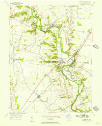 1955 Harrisburg1956 Print · USGSThe rural borderlands of Franklin, Pickaway, and Madison counties come to life in the mid-fifties as the Baltimore and Ohio Railroad connects the towns of Orient and Derby. Researchers can trace the grounds of the Orient State Institute or locate family plots at Little Pennsylvania Cem and McKinley Cem.
 - 1958 Map of Five Points, 1959 Print
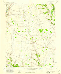 1958 Five Points1959 Print · USGSPickaway County farming life is captured in the late fifties as a network of rural roads connects local hubs like Five Points and Era. Genealogists and historians can trace family-named landmarks and routes like Whiteside-Lister Mill Road and Thomas Cem.4 unique versions available
End of results
Showing maps 1-2 of 2
Top cities near Darby Township
- Columbus historical maps
- Grove City historical maps
- London historical maps
- Grandview Heights historical maps
- West Jefferson historical maps
- Obetz historical maps
See more
Top neighborhoods of Darby Township
Frequently asked questions
- What are the different types of historical maps available for Darby Township?
- What is the oldest map of Darby Township?
- Where can I purchase historical maps of Darby Township for my home or office?
- Where can I download high-res historical maps of Darby Township?
- Are there historical topographic maps available for Darby Township?
- Is there historical aerial imagery available for Darby Township?
- Where are historical maps of Darby Township sourced from?