1990s Maps of Walnut Township, Ohio
Explore 2 historic maps of Walnut Township from the 1990s. These maps offer a rare glimpse into what life looked like during the 1990s — showing old roads, neighborhoods, homes, and landmarks that have changed or disappeared over time.
Whether you're researching your family's past, planning a metal detecting trip, or studying how Walnut Township's landscape evolved across the 1990s, these high-resolution maps are a powerful tool for exploring the history of this region.
- Focus on a specific era: All maps on this page are from the 1990s, giving you a focused view of this time period.
- See what’s changed: Compare century-old streets, trails, and buildings to today's modern landscape using overlays and satellite layers.
- Research with precision: Use these maps for genealogy, historical research, land use analysis, or educational projects.
- View, download, or print: Maps are fully viewable online in high resolution, and can be downloaded or printed for your own records.
Start exploring Walnut Township's history through authentic maps from the 1990s. This is your window into the past.
Walnut Township, OH maps
(2)- 1992 Map of Ashville, 1994 Print
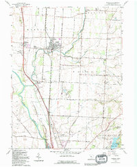 1992 Ashville1994 Print · USGSPickaway County settlement and agriculture are well-documented here during the early nineties as highway corridors expanded near older rail hubs. Researchers can trace family sites and civic history at Ashville, Millport, and the Reber Hill Cem.
 - 1992 Map of East Ringgold, 1995 Print
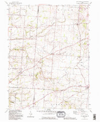 1992 East Ringgold1995 Print · USGSFairfield and Pickaway counties are shown in the 1990s, revealing a landscape of rural crossroads and historic cemeteries. Genealogists can trace East Union Cem, Ritter Cem, and family-named landmarks like Cedar Hill and Royalton.
End of results
Showing maps 1-2 of 2
Top cities near Walnut Township
- Columbus historical maps
- Lancaster historical maps
- Grove City historical maps
- Pickerington historical maps
- Circleville historical maps
- Groveport historical maps
See more
Top neighborhoods of Walnut Township
Frequently asked questions
- What are the different types of historical maps available for Walnut Township?
- What is the oldest map of Walnut Township?
- Where can I purchase historical maps of Walnut Township for my home or office?
- Where can I download high-res historical maps of Walnut Township?
- Are there historical topographic maps available for Walnut Township?
- Is there historical aerial imagery available for Walnut Township?
- Where are historical maps of Walnut Township sourced from?