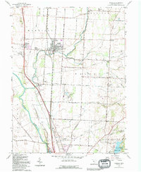
1992 Map of Ashville
USGS Topo · Published 1994About this map
Walnut Creek and its tributaries define the landscape of northern Pickaway County, where traditional agricultural patterns intersect with established rail and highway corridors. The village of Ashville serves as a central hub, flanked by the Norfolk and Western Railway and smaller neighborhoods like Little Chicago. Near the Scioto River, the historic settlements of South Bloomfield and Millport occupy the fertile plains west of the tracks. The presence of numerous family and community landmarks, such as Hoover Hill Cem and Hedges Chapel, provides a detailed record of local genealogy and nineteenth-century settlement patterns. To the south, the terrain transitions toward conservation and recreation at Stages Pond Natural Area and the waters of Hargus Lake within A W Marion State Park, illustrating the balance between working land and protected natural features in the Ohio countryside.
Find a feature on this map
56 named features on this map. Tap any name to fly to it.
Don’t see what you’re looking for? This feature index may not catch every label — zoom into the map to look around manually.
Map Details
Editions of this 1992 Ashville Map
This is the sole edition of this map. No revisions or reprints were ever made.
Other maps of this area

1911 · Era
USGS Topo · 1:62,500

1913 · Era
USGS Topo · 1:62,500

1914 · Circleville
USGS Topo · 1:62,500

1923 · West Columbus
USGS Topo · 1:62,500

1925 · East Columbus
USGS Topo · 1:62,500

1925 · West Columbus
USGS Topo · 1:62,500

1943 · Era
USGS Topo · 1:62,500

1943 · Circleville
USGS Topo · 1:62,500

1943 · East Columbus
USGS Topo · 1:62,500

1947 · Columbus
USGS Topo · 1:250,000