1960s Maps of Scioto County, Ohio
Explore 25 historic maps of Scioto County from the 1960s. These maps offer a rare glimpse into what life looked like during the 1960s — showing old roads, neighborhoods, homes, and landmarks that have changed or disappeared over time.
Whether you're researching your family's past, planning a metal detecting trip, or studying how Scioto County's landscape evolved across the 1960s, these high-resolution maps are a powerful tool for exploring the history of this region.
- Focus on a specific era: All maps on this page are from the 1960s, giving you a focused view of this time period.
- See what’s changed: Compare century-old streets, trails, and buildings to today's modern landscape using overlays and satellite layers.
- Research with precision: Use these maps for genealogy, historical research, land use analysis, or educational projects.
- View, download, or print: Maps are fully viewable online in high resolution, and can be downloaded or printed for your own records.
Start exploring Scioto County's history through authentic maps from the 1960s. This is your window into the past.
Scioto County, OH maps
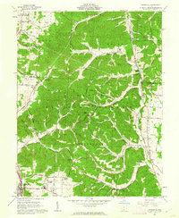
(25)- 1960 Map of Huntington
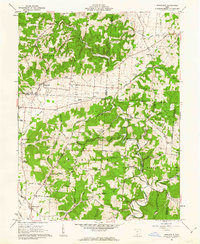
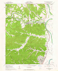
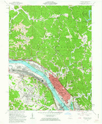
 1960 Huntington1960 Print · USGSThe tri-state river valley thrived in the late fifties as a hub of heavy industry and Appalachian rail transit. Genealogists and historians can trace the connection between river towns like Ashland and Portsmouth or locate family homesteads near Coleman Ridge.
 - 1961 Map of Columbus
 1961 Columbus1961 Print · USGSCentral and Southern Ohio are captured here in the early sixties, as the region's industrial rail hubs and military bases reached their peak. Genealogists and historians can trace the transition from urban Columbus to rural townships along the Scioto River, locating Lockbourne USAF and old junctions like Washington Court House.
 - 1961 Map of Stockdale, 1962 Print
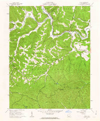
 1961 Stockdale1962 Print · USGSSouthern Ohio at the start of the 1960s reveals a patchwork of small-scale agriculture and timberlands within the Wayne National Forest. Genealogists and local historians can trace legacy landmarks like German Cemetery, the C & O Railroad corridor, and rural schools like Madison School.2 unique versions available
 - 1961 Map of Otway, 1962 Print
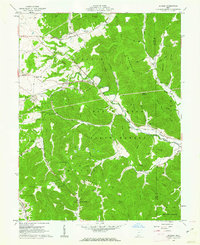
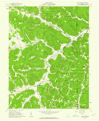
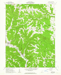
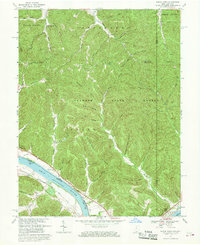
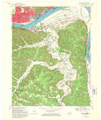
 1961 Otway1962 Print · USGSScioto County during the early 1960s was a landscape defined by state forests and the Norfolk and Western rail line. Researchers can trace rural life through the Township Sch, isolated family burial grounds like Oppy Cem, and landmarks such as the Copperhead Lookout Tower.3 unique versions available
 - 1961 Map of Jaybird, 1962 Print
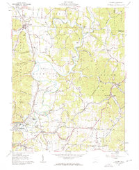
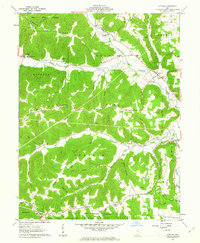
 1961 Jaybird1962 Print · USGSThe deep hollows and high ridges of the Ohio hill country are documented here in the early sixties, as the Norfolk and Western rail line served the timber and small farm economy. Local researchers can locate rural landmarks like Beaver Pond, Mineral Springs, and the Aikens Cem.5 unique versions available
 - 1961 Map of Minford, 1962 Print
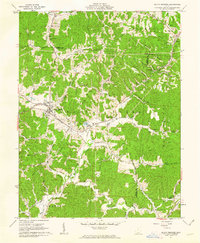
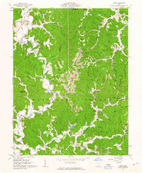
 1961 Minford1962 Print · USGSScioto County's hill country is captured here during the early sixties, showing a landscape defined by industrial history and small-town growth. You can trace early rail lines to Scioto Furnace or locate family plots at Bennett Cem and Lair Cem.2 unique versions available
 - 1961 Map of Lucasville, 1962 Print
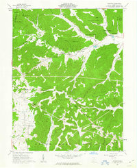
 1961 Lucasville1962 Print · USGSLucasville and the surrounding Scioto County timberlands are captured here in the early sixties, showing the expansion of residential additions along the valley floor. Genealogists can locate family burial grounds like Slavens Cem and Bennett Cem or trace the Chesapeake and Ohio rail line through the hills.3 unique versions available
 - 1961 Map of Blue Creek, 1962 Print
 1961 Blue Creek1962 Print · USGSSouthern Ohio in the early sixties remains a landscape of remote mountain peaks and deep hollows within the Shawnee State Forest. Researchers can trace old family sites and rural landmarks like the Township High Sch, Copas Cem, and Jones Corner.3 unique versions available
 - 1961 Map of New Boston, 1962 Print
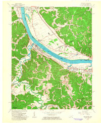
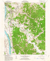
 1961 New Boston1962 Print · USGSThe Scioto and Ohio River valleys thrive in the early sixties as industrial expansion meets the wooded ridges of the southern hill country. Researchers can trace the river-and-rail infrastructure of New Boston or locate rural landmarks like Harrison Furnace and Stony Hill Cem.3 unique versions available
 - 1961 Map of South Webster, 1962 Print
 1961 South Webster1962 Print · USGSIn the early 1960s, this pocket of Scioto County remained a landscape of deep hollows and rail-linked industrial hamlets. Researchers can trace the roots of the local clay and iron trades at Olive Furnace, Firebrick, and the Bloom High Sch campus.2 unique versions available
 - 1961 Map of Rarden, 1963 Print
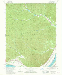
 1961 Rarden1963 Print · USGSScioto County during the early 1960s was a landscape of deep timber and winding hollows, largely defined by the Brush Creek State Forest. You can trace old family burial grounds like Old Hackworth Cem and follow the Norfolk and Western rail line through Rarden.4 unique versions available
 - 1961 Map of Latham, 1963 Print
 1961 Latham1963 Print · USGSPike County's rural valleys and steep ridges are captured here in the early sixties, showing a landscape defined by the Virginia Military District. Genealogists can locate family names at Arkoe Cem and Pennisten Chapel or trace the old roads near Latham.4 unique versions available
 - 1961 Map of Greenup, 1963 Print
 1961 Greenup1963 Print · USGSThe Ohio River valley in the early sixties was a bustling nexus of rail traffic and river commerce connecting Kentucky and Ohio. Genealogists can trace family roots through numerous hill-country burial sites like Womack Cemetery or locate landmarks such as Our Lady of Fatima Shrine and the Drive-in Theatre.
 - 1961 Map of Wakefield, 1963 Print
 1961 Wakefield1963 Print · USGSThe Scioto River valley and surrounding state forests are seen here in the early sixties as industrial development met the rural hills. Researchers can trace family sites like Rhymby Cem and Miller Cem, or find the Norfolk and Western line near the Scioto Canal.3 unique versions available
 - 1961 Map of West Portsmouth, 1963 Print
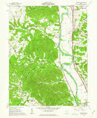
 1961 West Portsmouth1963 Print · USGSWest Portsmouth and the Scioto River valley are captured here in the early sixties, showing a landscape of deep ridges and riverside industry. Researchers can trace family roots at Scioto Burial Park or locate the ancient Tremper Mound and old quarries near McDermott.4 unique versions available
 - 1961 Map of Pedro, 1963 Print
 1961 Pedro1963 Print · USGSLawrence County's industrial and forest lands are captured here in the early sixties, showing the transition from iron furnaces to strip mining. Genealogists and historians can trace Detroit Toledo and Ironton RR stops and ruins like Buckhorn Furnace or Lawrence Furnace.4 unique versions available
 - 1961 Map of Byington, 1963 Print
 1961 Byington1963 Print · USGSSouthern Ohio in the early sixties was a land of timbered ridges and quiet creek valleys. Genealogists can trace family lines through Washburn Cem and Byington, or locate landmarks like the Kincaid Springs State Fish Hatchery.4 unique versions available
 - 1961 Map of Wheelersburg, 1963 Print
 1961 Wheelersburg1963 Print · USGSThe Ohio River valley in the early 1960s reveals a landscape defined by industry and community growth near Wheelersburg. Researchers can trace old property lines within the French Grants or locate landmarks like the Greenup Locks and Dam and the local Drive-in Theater.4 unique versions available
 - 1961 Map of Ironton, 1963 Print
 1961 Ironton1963 Print · USGSThe industrial river valley and the wooded hills of the Wayne National Forest meet in this early 1960s survey of the Ohio-Kentucky border. Genealogists can trace family names at Calvary Cem or locate community hubs like Quinn Chapel and the Vesuvius Furnace (Ruins).2 unique versions available
 - 1962 Map of Columbus
 1962 Columbus1962 Print · USGSCentral Ohio during the early sixties reveals a transition from the industrial corridors of Columbus to the forested ridges of the south. Genealogists and historians can trace the rail networks of the Baltimore & Ohio RR and find local landmarks like Washington Court House and Camp Sherman Military Reservation.
 - 1967 Map of Buena Vista, 1969 Print
 1967 Buena Vista1969 Print · USGSThe Ohio River valley near the Scioto and Adams county line shows a landscape of deep timbered hollows and riverside rail life in the late sixties. Researchers can trace the path of the Chesapeake and Ohio railroad or locate local landmarks like Quick Run Chapel and the Twin Creek Lookout Tower.2 unique versions available
 - 1967 Map of Columbus, 1969 Print
 1967 Columbus1969 Print · USGSCentral Ohio during the late sixties serves as a vital corridor of rail and aviation, from the industrial streets of Springfield to the hangar lines of Lockbourne Air Force Base. Genealogists and researchers can trace the growth of towns like Circleville and London or locate rural landmarks such as St Paul church and the London Correctional Institution.2 unique versions available
 - 1967 Map of Pond Run, 1970 Print
 1967 Pond Run1970 Print · USGSThe Ohio River hills and the deep valleys of the Shawnee State Forest are recorded here in the late sixties. Researchers can trace the quiet reaches of Turkey Creek and locate family landmarks like McDermott Cem and McKendree Ch.3 unique versions available
 - 1968 Map of Friendship, 1970 Print
 1968 Friendship1970 Print · USGSThe Ohio River borderlands are seen here in the late sixties, where industrial valleys meet the forested ridges of Shawnee State Forest. Genealogists can trace family landmarks like Vaughters Cem, Stony Run Tabernacle, and Morris Hill Ch.3 unique versions available
 - 1968 Map of Portsmouth, 1970 Print
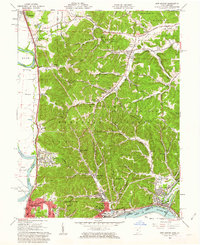
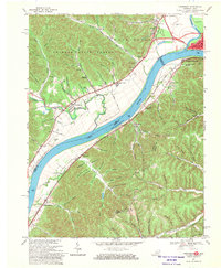
 1968 Portsmouth1970 Print · USGSThe Ohio River valley at Portsmouth and South Shore was a bustling corridor of rail and river industry in the late sixties. Genealogists and local historians can trace the foundations of New Boston and South Portsmouth, or find rural landmarks like Globe Ch and Fannin Cem.2 unique versions available
End of results
Showing maps 1-25 of 25
Top cities of Scioto County
- Portsmouth historical maps
- New Boston historical maps
- South Webster historical maps
- Rarden historical maps
- Otway historical maps
Frequently asked questions
- What are the different types of historical maps available for Scioto County?
- What is the oldest map of Scioto County?
- Where can I purchase historical maps of Scioto County for my home or office?
- Where can I download high-res historical maps of Scioto County?
- Are there historical topographic maps available for Scioto County?
- Is there historical aerial imagery available for Scioto County?
- Where are historical maps of Scioto County sourced from?