1960s Maps of Lucasville, Ohio
Explore 5 historic maps of Lucasville from the 1960s. These maps offer a rare glimpse into what life looked like during the 1960s — showing old roads, neighborhoods, homes, and landmarks that have changed or disappeared over time.
Whether you're researching your family's past, planning a metal detecting trip, or studying how Lucasville's landscape evolved across the 1960s, these high-resolution maps are a powerful tool for exploring the history of this region.
- Focus on a specific era: All maps on this page are from the 1960s, giving you a focused view of this time period.
- See what’s changed: Compare century-old streets, trails, and buildings to today's modern landscape using overlays and satellite layers.
- Research with precision: Use these maps for genealogy, historical research, land use analysis, or educational projects.
- View, download, or print: Maps are fully viewable online in high resolution, and can be downloaded or printed for your own records.
Start exploring Lucasville's history through authentic maps from the 1960s. This is your window into the past.
Lucasville, OH maps
(5)- 1960 Map of Huntington
 1960 Huntington1960 Print · USGSThe tri-state river valley thrived in the late fifties as a hub of heavy industry and Appalachian rail transit. Genealogists and historians can trace the connection between river towns like Ashland and Portsmouth or locate family homesteads near Coleman Ridge.
 - 1961 Map of Lucasville, 1962 Print
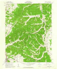 1961 Lucasville1962 Print · USGSLucasville and the surrounding Scioto County timberlands are captured here in the early sixties, showing the expansion of residential additions along the valley floor. Genealogists can locate family burial grounds like Slavens Cem and Bennett Cem or trace the Chesapeake and Ohio rail line through the hills.3 unique versions available
 - 1961 Map of New Boston, 1962 Print
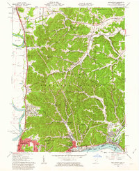 1961 New Boston1962 Print · USGSThe Scioto and Ohio River valleys thrive in the early sixties as industrial expansion meets the wooded ridges of the southern hill country. Researchers can trace the river-and-rail infrastructure of New Boston or locate rural landmarks like Harrison Furnace and Stony Hill Cem.3 unique versions available
 - 1961 Map of Wakefield, 1963 Print
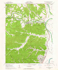
 1961 Wakefield1963 Print · USGSThe Scioto River valley and surrounding state forests are seen here in the early sixties as industrial development met the rural hills. Researchers can trace family sites like Rhymby Cem and Miller Cem, or find the Norfolk and Western line near the Scioto Canal.3 unique versions available
 - 1961 Map of West Portsmouth, 1963 Print
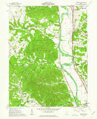
 1961 West Portsmouth1963 Print · USGSWest Portsmouth and the Scioto River valley are captured here in the early sixties, showing a landscape of deep ridges and riverside industry. Researchers can trace family roots at Scioto Burial Park or locate the ancient Tremper Mound and old quarries near McDermott.4 unique versions available
End of results
Showing maps 1-5 of 5
Top cities near Lucasville
- Portsmouth historical maps
- New Boston historical maps
- Piketon historical maps
- Beaver historical maps
- Otway historical maps
Top neighborhoods of Lucasville
Frequently asked questions
- What are the different types of historical maps available for Lucasville?
- What is the oldest map of Lucasville?
- Where can I purchase historical maps of Lucasville for my home or office?
- Where can I download high-res historical maps of Lucasville?
- Are there historical topographic maps available for Lucasville?
- Is there historical aerial imagery available for Lucasville?
- Where are historical maps of Lucasville sourced from?