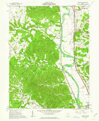
1961 Map of Wakefield
USGS Topo · Published 1963About this map
Scioto River valley bottomlands and the timbered ridges of the Wayne National Forest dominate this early 1960s landscape north of Lucasville. The region is defined by a dense network of forest preserves, including the Camp Creek State Forest and Brush Creek State Forest, where numerous family-named landmarks like Mt Ettney Cem and Merritt Cem mark the heritage of upland settlers. The eastern corridor follows the Norfolk and Western railroad and the historic path of the Scioto Canal, anchoring settlements like Wakefield and Coopersville. A significant modern footprint appears in the northeast, where the U S Reservation Atomic Energy Commission sits adjacent to the Scioto Trail State Park, illustrating the mid-century transition from traditional agriculture and forestry toward large-scale government infrastructure.
Find a feature on this map
73 named features on this map. Tap any name to fly to it.
Don’t see what you’re looking for? This feature index may not catch every label — zoom into the map to look around manually.
Map Details
Editions of this 1961 Wakefield Map
3 editions found
Other maps of this area

1906 · Waverly
USGS Topo · 1:62,500

1908 · Waverly
USGS Topo · 1:62,500

1911 · Sciotoville
USGS Topo · 1:62,500

1913 · Sciotoville
USGS Topo · 1:62,500

1915 · Otway
USGS Topo · 1:62,500

1915 · Piketon
USGS Topo · 1:62,500

1917 · Piketon
USGS Topo · 1:62,500

1917 · Otway
USGS Topo · 1:62,500

1944 · Piketon
USGS Topo · 1:62,500

1947 · Columbus
USGS Topo · 1:250,000