
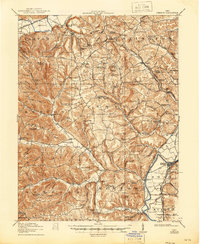
1917 Map of Piketon
USGS Topo · Published 1934About this map
The Scioto River valley serves as the primary corridor for settlement and industry in this early twentieth-century survey, anchored by the town of Piketon. Evidence of ancient habitation is clearly marked at Seip Mound near Paint Creek and the Mound Cemetery to the south. The landscape is defined by a dense network of country schools, including Turkey Run School and Yankee Hill School, serving rural communities like Latham and Jasper. Transportation is dominated by the Detroit Toledo and Ironton Railroad and the Norfolk and Western Railway, which parallel the river and connect smaller stops such as Sargents. The surrounding uplands are characterized by dozens of named knobs and ridges, such as Horseback Knob and Greenbrier Ridge, where isolated post offices like Bethel Pike PO supported the dispersed population before the era of modern road consolidation.
Find a feature on this map
145 named features on this map. Tap any name to fly to it.
Don’t see what you’re looking for? This feature index may not catch every label — zoom into the map to look around manually.
Map Details
Editions of this 1917 Piketon Map
2 editions found
Other maps of this area

1906 · Waverly
USGS Topo · 1:62,500

1906 · Chillicothe
USGS Topo · 1:62,500

1908 · Chillicothe
USGS Topo · 1:62,500

1908 · Waverly
USGS Topo · 1:62,500

1911 · Sciotoville
USGS Topo · 1:62,500

1912 · Roxabell
USGS Topo · 1:62,500

1913 · Sciotoville
USGS Topo · 1:62,500

1914 · Roxabell
USGS Topo · 1:62,500

1915 · Bainbridge
USGS Topo · 1:48,000

1915 · Otway
USGS Topo · 1:62,500