
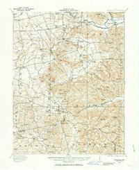
1915 Map of Bainbridge
USGS Topo · Published 1915About this map
Paint Creek winds through the northeast corner of this 1915 survey, where the settlement of Bainbridge sits near an Indian Mound and the Bainbridge Cemetery. The landscape transitions from the broader valleys of the north to the dissected, higher ground of Bakers Hill and Smith Hill in the south and east. This era captures a rural network of schoolhouses and country churches spaced for foot and horse travel, serving a community tied to the land across Highland, Ross, and Pike counties.
Find a feature on this map
28 named features on this map. Tap any name to fly to it.
Don’t see what you’re looking for? This feature index may not catch every label — zoom into the map to look around manually.
Map Details
Editions of this 1915 Bainbridge Map
2 editions found
Other maps of this area

1912 · Roxabell
USGS Topo · 1:62,500

1914 · Roxabell
USGS Topo · 1:62,500

1915 · Otway
USGS Topo · 1:62,500

1915 · Piketon
USGS Topo · 1:62,500

1916 · Peebles
USGS Topo · 1:62,500

1917 · Bainbridge
USGS Topo · 1:62,500

1917 · Piketon
USGS Topo · 1:62,500

1917 · Greenfield
USGS Topo · 1:62,500

1917 · Hillsboro
USGS Topo · 1:62,500

1917 · Otway
USGS Topo · 1:62,500