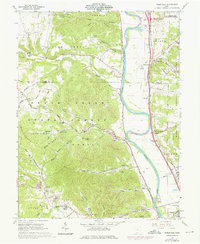
1961 Map of Wakefield
USGS Topo · Published 1976About this map
The Scioto River valley serves as a primary corridor for transportation and industry, where the Norfolk and Western railroad and state highways parallel the river's winding course. This landscape is characterized by the complex transition between the established riverfront settlements and the heavily dissected ridges of the Scioto State Forest and Wayne National Forest. Notable among the industrial and civic developments of the early 1960s is the presence of the U S Reservation Atomic Energy Commission in the northeast and the County Fairgrounds near Lucasville. Away from the main valley, local life is anchored by dispersed landmarks like Mt Zion Ch, the Township Sch, and numerous family burial grounds such as Merritt Cem and Miller Cem. The terrain rises sharply toward Henderson Knob, revealing a network of hollows including Starr Hollow and Wildcat Hollow that define the local geography.
Find a feature on this map
77 named features on this map. Tap any name to fly to it.
Don’t see what you’re looking for? This feature index may not catch every label — zoom into the map to look around manually.
Map Details
Editions of this 1961 Wakefield Map
3 editions found
Other maps of this area

1906 · Waverly
USGS Topo · 1:62,500

1908 · Waverly
USGS Topo · 1:62,500

1911 · Sciotoville
USGS Topo · 1:62,500

1913 · Sciotoville
USGS Topo · 1:62,500

1915 · Otway
USGS Topo · 1:62,500

1915 · Piketon
USGS Topo · 1:62,500

1917 · Piketon
USGS Topo · 1:62,500

1917 · Otway
USGS Topo · 1:62,500

1944 · Piketon
USGS Topo · 1:62,500

1947 · Columbus
USGS Topo · 1:250,000