1960s Maps of Williams County, Ohio
Explore 11 historic maps of Williams County from the 1960s. These maps offer a rare glimpse into what life looked like during the 1960s — showing old roads, neighborhoods, homes, and landmarks that have changed or disappeared over time.
Whether you're researching your family's past, planning a metal detecting trip, or studying how Williams County's landscape evolved across the 1960s, these high-resolution maps are a powerful tool for exploring the history of this region.
- Focus on a specific era: All maps on this page are from the 1960s, giving you a focused view of this time period.
- See what’s changed: Compare century-old streets, trails, and buildings to today's modern landscape using overlays and satellite layers.
- Research with precision: Use these maps for genealogy, historical research, land use analysis, or educational projects.
- View, download, or print: Maps are fully viewable online in high resolution, and can be downloaded or printed for your own records.
Start exploring Williams County's history through authentic maps from the 1960s. This is your window into the past.
Williams County, OH maps
(11)- 1960 Map of Evansport, 1961 Print
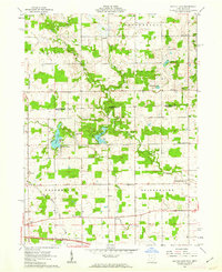
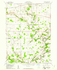 1960 Evansport1961 Print · USGSNorthwest Ohio at the dawn of the sixties shows a landscape shaped by the winding Tiffin River and the New York Central rail line. Genealogists can trace family landmarks like Evansport Cem, Oak Grove Ch, and the Township High Sch near Evansport.2 unique versions available
 - 1960 Map of Bryan, 1961 Print
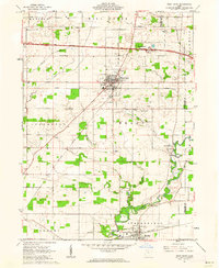
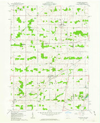
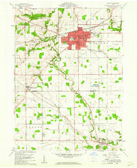 1960 Bryan1961 Print · USGSThe Northwest Ohio landscape of the early sixties comes alive around Bryan and the winding Lick Creek. Genealogists and local historians can trace rural roots through Brown Cem, Washington Sch, and the small settlement of Ney.4 unique versions available
 - 1961 Map of Edgerton, 1962 Print
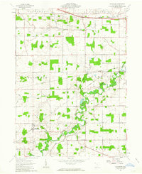
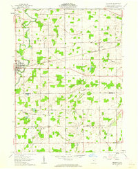 1961 Edgerton1962 Print · USGSIn the early sixties, the Williams and Defiance County line was a landscape of quiet crossroads and bustling rail stops. Trace family history and rural industry through Edgerton, the trackside hamlet of Mina, and local landmarks like Tamarack Cem.3 unique versions available
 - 1961 Map of Pioneer, 1962 Print
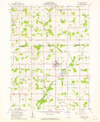 1961 Pioneer1962 Print · USGSNorthwestern Ohio meets the Michigan border in the early 1960s, centered on the village of Pioneer. Genealogists can trace family roots through numerous local landmarks like Floral Grove Cem, Cogswell Cem, and Amboy Ch.3 unique versions available
 - 1961 Map of West Unity, 1962 Print
 1961 West Unity1962 Print · USGSWilliams County at the start of the sixties shows a landscape defined by the Tiffin River and the new Ohio Turnpike. Researchers can trace family history at the Quaker Ch Cem or explore the rail era through West Unity and Stryker.2 unique versions available
 - 1961 Map of Clear Lake, 1963 Print
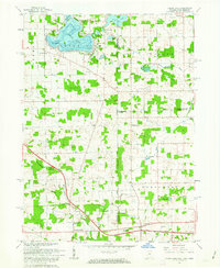 1961 Clear Lake1963 Print · USGSThe tri-state junction of Indiana, Ohio, and Michigan comes alive in the early sixties as a crossroads of high-speed travel and quiet lakeside life. Researchers can trace the connection between the Indiana Toll Road and the Ohio Turnpike or locate family roots at Teeters Cemetery and Powers Church.3 unique versions available
 - 1961 Map of Edon, 1963 Print
 1961 Edon1963 Print · USGSIn the early 1960s, this tri-state border region centered on Edon highlights a landscape of river-fed farms and remote rural settlements. Researchers can locate historic landmarks like the Covered Bridge and family heritage sites such as Eddy Cem and Zion Ch.4 unique versions available
 - 1961 Map of Montpelier, 1963 Print
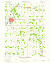 1961 Montpelier1963 Print · USGSMontpelier and the surrounding Williams County townships are shown here in the early sixties as modern turnpikes and airports began to change the rural landscape. Researchers can trace family roots at Riverside Cem, visit the County Home, or locate the West Bethesda Ch.2 unique versions available
 - 1961 Map of Nettle Lake, 1963 Print
 1961 Nettle Lake1963 Print · USGSThe Ohio-Michigan borderlands appear in the early sixties as a patchwork of farms and glacial lakes. Genealogists can trace property lines and family landmarks like Malcom Cem, Nettle Lake Ch, and the small settlement of Cooney.3 unique versions available
 - 1961 Map of Alvordton, 1963 Print
 1961 Alvordton1963 Print · USGSCrossing the Michigan-Ohio border in the early sixties, this area reveals a network of small rail towns and rural parishes. Researchers can trace family history at Walnut Grove Cem, locate the former Franklin Junction rail stop, or explore the grounds of Harrison Lake State Reservation.2 unique versions available
 - 1961 Map of Blakeslee, 1963 Print
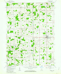
 1961 Blakeslee1963 Print · USGSNorthwest Ohio's rural landscape is captured here in the early sixties, where the river and rail lines dictated the pace of life. Genealogists can trace family names through landmarks like Heritage Cem, Union Chapel, and the West Buffalo Cem.2 unique versions available
End of results
Showing maps 1-11 of 11
Top cities of Williams County
Frequently asked questions
- What are the different types of historical maps available for Williams County?
- What is the oldest map of Williams County?
- Where can I purchase historical maps of Williams County for my home or office?
- Where can I download high-res historical maps of Williams County?
- Are there historical topographic maps available for Williams County?
- Is there historical aerial imagery available for Williams County?
- Where are historical maps of Williams County sourced from?