1950s Maps of Cherokee County, Oklahoma
Explore 5 historic maps of Cherokee County from the 1950s. These maps offer a rare glimpse into what life looked like during the 1950s — showing old roads, neighborhoods, homes, and landmarks that have changed or disappeared over time.
Whether you're researching your family's past, planning a metal detecting trip, or studying how Cherokee County's landscape evolved across the 1950s, these high-resolution maps are a powerful tool for exploring the history of this region.
- Focus on a specific era: All maps on this page are from the 1950s, giving you a focused view of this time period.
- See what’s changed: Compare century-old streets, trails, and buildings to today's modern landscape using overlays and satellite layers.
- Research with precision: Use these maps for genealogy, historical research, land use analysis, or educational projects.
- View, download, or print: Maps are fully viewable online in high resolution, and can be downloaded or printed for your own records.
Start exploring Cherokee County's history through authentic maps from the 1950s. This is your window into the past.
Cherokee County, OK maps
(5)- 1950 Map of Wagoner
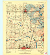 1950 Wagoner1950 Print · USGSMid-century eastern Oklahoma is captured here as the Fort Gibson Reservoir project begins to reshape the river valleys. Genealogists and local historians can trace rural school districts and family landmarks from Tullahassee to the Murrow Ind Orphans Home.2 unique versions available
 - 1950 Map of Hulbert
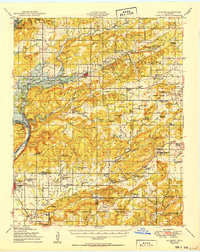 1950 Hulbert1950 Print · USGSOklahoma's Cherokee County appears here at a pivotal moment just after the war, as the Gibson Reservoir begins to reshape the landscape. Researchers can trace dozens of rural landmarks, including the Sequoyah Indian School, the Fort Gibson National Cemetery, and the Camp Gruber Military Reservation.2 unique versions available
 - 1950 Map of Webbers Falls
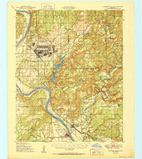 1950 Webbers Falls1950 Print · USGSMid-century Muskogee County is captured here as a landscape of military readiness and Cherokee heritage. Researchers can trace the infrastructure of Camp Gruber or locate local landmarks like the Sour John Indian Sch and Howard Chapel.2 unique versions available
 - 1954 Map of Tulsa
 1954 Tulsa1954 Print · USGSNortheast Oklahoma and the Ozark border are shown here during a period of massive industrial and infrastructure growth. Researchers can trace the legacy of the Tri-State Mining District and the development of major reservoirs like Grand Lake O' The Cherokees.2 unique versions available
 - 1958 Map of Tulsa, 1968 Print
 1958 Tulsa1968 Print · USGSNortheast Oklahoma and the Ozark borderlands are captured here during a massive era of reservoir construction and highway expansion. Researchers can trace the mid-century footprints of Tulsa, the sprawling Lake O' the Cherokees, and historical sites like Pea Ridge National Military Park.3 unique versions available
End of results
Showing maps 1-5 of 5
Top cities of Cherokee County
Frequently asked questions
- What are the different types of historical maps available for Cherokee County?
- What is the oldest map of Cherokee County?
- Where can I purchase historical maps of Cherokee County for my home or office?
- Where can I download high-res historical maps of Cherokee County?
- Are there historical topographic maps available for Cherokee County?
- Is there historical aerial imagery available for Cherokee County?
- Where are historical maps of Cherokee County sourced from?