
1950 Map of Wagoner
USGS Topo · Published 1950About this map
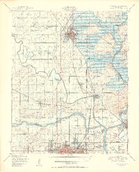
The confluence of the Verdigris River, Arkansas River, and Neosho River defines this 1950 survey of eastern Oklahoma, a landscape shaped by both natural waterways and massive engineering projects. The Fort Gibson Reservoir is shown in its nascent stage, with the anticipated shoreline and dam site clearly marked. This era finds the region at a crossroads between its deep institutional roots, such as the Bacone College campus and the Murrow Ind Orphans Home, and the industrial expansion signaled by five major rail lines, including the Kansas Oklahoma and Gulf and the Midland Valley.
Find a feature on this map
79 named features on this map. Tap any name to fly to it.
Don’t see what you’re looking for? This feature index may not catch every label — zoom into the map to look around manually.
Map Details
Editions of this 1950 Wagoner Map
2 editions found
Other maps of this area

1896 · Okmulgee
USGS Topo · 1:125,000

1896 · Pryor
USGS Topo · 1:125,000

1900 · Okmulgee
USGS Topo · 1:125,000

1901 · Muscogee
USGS Topo · 1:125,000

1901 · Claremore
USGS Topo · 1:125,000

1901 · Pryor
USGS Topo · 1:125,000

1905 · Muscogee
USGS Topo · 1:125,000

1914 · Claremore
USGS Topo · 1:125,000

1916 · Claremore
USGS Topo · 1:125,000

1946 · Fort Smith
USGS Topo · 1:250,000