1970s Maps of Tahlequah, Oklahoma
Explore 7 historic maps of Tahlequah from the 1970s. These maps offer a rare glimpse into what life looked like during the 1970s — showing old roads, neighborhoods, homes, and landmarks that have changed or disappeared over time.
Whether you're researching your family's past, planning a metal detecting trip, or studying how Tahlequah's landscape evolved across the 1970s, these high-resolution maps are a powerful tool for exploring the history of this region.
- Focus on a specific era: All maps on this page are from the 1970s, giving you a focused view of this time period.
- See what’s changed: Compare century-old streets, trails, and buildings to today's modern landscape using overlays and satellite layers.
- Research with precision: Use these maps for genealogy, historical research, land use analysis, or educational projects.
- View, download, or print: Maps are fully viewable online in high resolution, and can be downloaded or printed for your own records.
Start exploring Tahlequah's history through authentic maps from the 1970s. This is your window into the past.
Tahlequah, OK maps
(7)- 1972 Map of Hulbert NE, 1974 Print
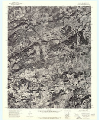 1972 Hulbert NE1974 Print · USGSCherokee County appears in high-resolution detail in the early seventies, showing a landscape defined by cattle ranching and dense woodland. Genealogists and historians can trace property boundaries and land use near Kolpin Mountain and the banks of Fourteenmile Creek.
 - 1972 Map of Tahlequah, 1974 Print
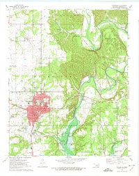 1972 Tahlequah1974 Print · USGSTahlequah and the Illinois River valley are captured in the early 1970s, showcasing a mix of academic growth and riverfront geography. Genealogists and historians can trace the footprint of Northeastern State College, locate the Manus Cem, and follow the OLD RAILROAD GRADE through the hills.3 unique versions available
 - 1973 Map of Park Hill, 1974 Print
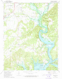 1973 Park Hill1974 Print · USGSNear the Illinois River in the 1970s, this Cherokee County landscape reveals a deep history of settlement and community life. Researchers can locate family sites at Ross Cem, explore Tsa La Gi Indian Village, or trace the shoreline near Carters Landing.2 unique versions available
 - 1974 Map of Thompson Corner, 1978 Print
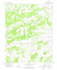 1974 Thompson Corner1978 Print · USGSCherokee County in the mid-seventies is documented here as a landscape of rural communities and hilltop cemeteries. Genealogists and local historians can trace family roots through landmarks like Thompson Corner, New Hope Ch, and the Houston Cem.
 - 1978 Map of Muskogee, 1979 Print
 1978 Muskogee1979 Print · USGSThe confluence of the Arkansas, Verdigris, and Neosho Rivers defines the Muskogee region in the late seventies. Genealogists and historians can trace the footprints of Camp Gruber (Abandoned), the campus of Bacone College, and early aviation at Hatbox Field.
 - 1978 Map of Fort Smith, 1979 Print
 1978 Fort Smith1979 Print · USGSThe Arkansas-Oklahoma borderlands in the late seventies show a landscape shaped by massive river reservoirs and sprawling military reservations. Trace the historic rail lines of the Missouri Pacific RR and locate regional landmarks like Fort Gibson, Tenkiller Ferry Lake, and Barling.2 unique versions available
 - 1978 Map of Stilwell, 1979 Print
 1978 Stilwell1979 Print · USGSThe Oklahoma-Arkansas borderlands come alive in the late seventies, showing the transition from the Cherokee Nation hills to the Arkansas Ozarks. Researchers can trace the Kansas City Southern rail line through Stilwell, find Wrights Chapel, or locate the Northeastern State College campus in Tahlequah.
End of results
Showing maps 1-7 of 7
Top cities near Tahlequah
Top neighborhoods of Tahlequah
Frequently asked questions
- What are the different types of historical maps available for Tahlequah?
- What is the oldest map of Tahlequah?
- Where can I purchase historical maps of Tahlequah for my home or office?
- Where can I download high-res historical maps of Tahlequah?
- Are there historical topographic maps available for Tahlequah?
- Is there historical aerial imagery available for Tahlequah?
- Where are historical maps of Tahlequah sourced from?