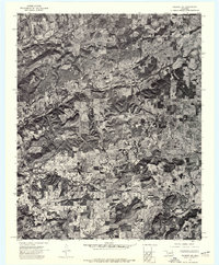
1972 Map of Hulbert NE
USGS Topo · Published 1974About this map
Fourteenmile Creek and Double Spring Creek carve through the wooded landscape of Cherokee County in this early 1970s orthophotoquad. Unlike traditional line-drawn maps, this aerial imagery provides a direct view of the dense vegetation and agricultural clearings that define the region. High points like Kolpin Mountain and Sugar Mountain rise distinctly above the creek bottoms, revealing the relationship between the area's relief and its land use. The imagery shows a network of section-line roads and farmsteads, reflecting a rural Oklahoma economy focused on timber and livestock grazing. This survey captures the exact state of the forest cover and field boundaries as they existed during the winter of 1972.
Find a feature on this map
4 named features on this map. Tap any name to fly to it.
Don’t see what you’re looking for? This feature index may not catch every label — zoom into the map to look around manually.
Map Details
Editions of this 1972 Hulbert NE Map
This is the sole edition of this map. No revisions or reprints were ever made.
Other maps of this area

1896 · Pryor
USGS Topo · 1:125,000

1898 · Tahlequah
USGS Topo · 1:125,000

1899 · Siloam Springs
USGS Topo · 1:125,000

1901 · Muscogee
USGS Topo · 1:125,000

1901 · Pryor
USGS Topo · 1:125,000

1901 · Tahlequah
USGS Topo · 1:125,000

1903 · Siloam Springs
USGS Topo · 1:125,000

1904 · Siloam Springs
USGS Topo · 1:125,000

1905 · Muscogee
USGS Topo · 1:125,000

1905 · Tahlequah
USGS Topo · 1:125,000