1950s Maps of Choctaw County, Oklahoma
Explore 8 historic maps of Choctaw County from the 1950s. These maps offer a rare glimpse into what life looked like during the 1950s — showing old roads, neighborhoods, homes, and landmarks that have changed or disappeared over time.
Whether you're researching your family's past, planning a metal detecting trip, or studying how Choctaw County's landscape evolved across the 1950s, these high-resolution maps are a powerful tool for exploring the history of this region.
- Focus on a specific era: All maps on this page are from the 1950s, giving you a focused view of this time period.
- See what’s changed: Compare century-old streets, trails, and buildings to today's modern landscape using overlays and satellite layers.
- Research with precision: Use these maps for genealogy, historical research, land use analysis, or educational projects.
- View, download, or print: Maps are fully viewable online in high resolution, and can be downloaded or printed for your own records.
Start exploring Choctaw County's history through authentic maps from the 1950s. This is your window into the past.
Choctaw County, OK maps
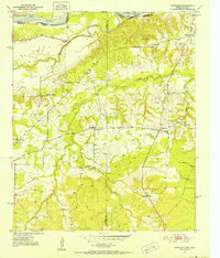
(8)- 1950 Map of Mcalester
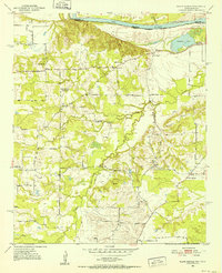
 1950 Mcalester1950 Print · USGSThe Ouachita Mountains and the coal country of Southeast Oklahoma are shown here in the late 1940s. Genealogists and historians can trace the rail-driven growth of McAlester, Wilburton, and Antlers alongside the rugged terrain of Kiamichi Mountain.2 unique versions available
 - 1951 Map of Slate Shoals, 1952 Print
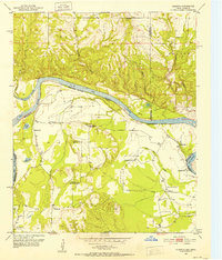
 1951 Slate Shoals1952 Print · USGSLamar County, Texas, and Choctaw County, Oklahoma, are separated by the winding Red River in this early 1950s study. Genealogists can locate several remote landmarks, including the Pee Dee Sch and rural burials at Newbether Cem.3 unique versions available
 - 1951 Map of Frogville, 1952 Print
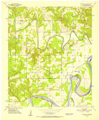 1951 Frogville1952 Print · USGSThe Oklahoma-Texas borderlands along the Red River are captured here in the early fifties, showing a landscape defined by meandering river bends. Genealogists can locate numerous local burial sites and schools like Frogville Cem, Everidge Cem, and Lake View Sch.3 unique versions available
 - 1951 Map of Shoals, 1952 Print
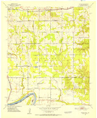 1951 Shoals1952 Print · USGSThe northern banks of the Red River are captured here in the early fifties, showing a rural community defined by its schools and rail lines. Genealogists can trace family landmarks like Shoat Springs Cem, Ervin Sch, and the settlement of Shoals.2 unique versions available
 - 1951 Map of Kiomatia, 1952 Print
 1951 Kiomatia1952 Print · USGSThe Red River valley at the Texas-Oklahoma border comes alive in the early fifties, showing a dense network of rural schools and river-bottom farms. Genealogists can trace family footprints at Kiomatia, Siloam Church, and the Kiomatia Agricultural School.
 - 1951 Map of Woodland, 1952 Print
 1951 Woodland1952 Print · USGSThe Red River Valley's borderlands in the early fifties are captured here as a landscape of small agricultural hamlets and riverfront boundaries. Researchers can trace rural community life through landmarks like Lone Star Sch, Woodland Cem, and the crossing at Pin Hook.2 unique versions available
 - 1953 Map of Texarkana, 1964 Print
 1953 Texarkana1964 Print · USGSThe Texas-Arkansas borderlands are captured here in the mid-fifties, during a decade of massive military and hydraulic engineering projects. Genealogists and researchers can locate family landmarks like Old Boston Cem, Siloam Ch, and the vast Red River Arsenal.4 unique versions available
 - 1956 Map of Texarkana
 1956 Texarkana1956 Print · USGSThe Ark-La-Tex borderlands come alive in the mid-fifties, showing the transition from a rail-dependent rural economy to a post-war industrial landscape. Researchers can trace the massive Red River Ordnance Depot and find towns like Talco, Bogata, and Naples.
End of results
Showing maps 1-8 of 8
Top cities of Choctaw County
- Hugo historical maps
- Boswell historical maps
- Fort Towson historical maps
- Sawyer historical maps
- Soper historical maps
- Grant historical maps
Frequently asked questions
- What are the different types of historical maps available for Choctaw County?
- What is the oldest map of Choctaw County?
- Where can I purchase historical maps of Choctaw County for my home or office?
- Where can I download high-res historical maps of Choctaw County?
- Are there historical topographic maps available for Choctaw County?
- Is there historical aerial imagery available for Choctaw County?
- Where are historical maps of Choctaw County sourced from?