1970s Maps of Choctaw County, Oklahoma
Explore 4 historic maps of Choctaw County from the 1970s. These maps offer a rare glimpse into what life looked like during the 1970s — showing old roads, neighborhoods, homes, and landmarks that have changed or disappeared over time.
Whether you're researching your family's past, planning a metal detecting trip, or studying how Choctaw County's landscape evolved across the 1970s, these high-resolution maps are a powerful tool for exploring the history of this region.
- Focus on a specific era: All maps on this page are from the 1970s, giving you a focused view of this time period.
- See what’s changed: Compare century-old streets, trails, and buildings to today's modern landscape using overlays and satellite layers.
- Research with precision: Use these maps for genealogy, historical research, land use analysis, or educational projects.
- View, download, or print: Maps are fully viewable online in high resolution, and can be downloaded or printed for your own records.
Start exploring Choctaw County's history through authentic maps from the 1970s. This is your window into the past.
Choctaw County, OK maps
(4)- 1971 Map of Spencerville, 1973 Print
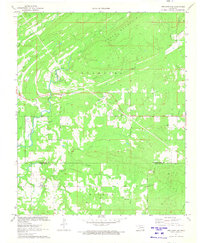 1971 Spencerville1973 Print · USGSSoutheast Oklahoma in the early seventies shows a landscape of timbered ridges and quiet creek valleys along the Choctaw and Pushmataha county line. Genealogists and local historians can locate rural landmarks like Spencerville Ch, Oleta, and Blackjack Ch.
 - 1971 Map of Fort Towson, 1973 Print
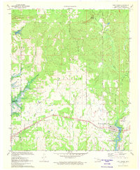 1971 Fort Towson1973 Print · USGSChoctaw County at the start of the 1970s reveals a landscape undergoing significant changes as new reservoirs began to shape the terrain. Researchers can locate the Old Fort Towson ruins, trace the St Louis - San Francisco rail line, and find family names near Box Springs Church.
 - 1971 Map of Hugo Dam, 1973 Print
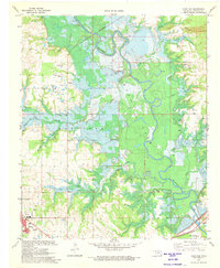 1971 Hugo Dam1973 Print · USGSThe Kiamichi River valley was on the verge of change in the early seventies as the Hugo Dam began to reshape the landscape. Genealogists and historians can trace family-named sites like Messer Cem, Dixon Chapel Cem, and Nash Airport.
 - 1971 Map of Rattan, 1973 Print
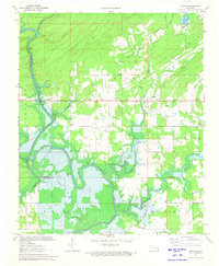 1971 Rattan1973 Print · USGSThe Kiamichi River valley was undergoing a major transformation in the early seventies as the waters of Hugo Lake began to rise. Genealogists and local historians can trace family locations near Belzoni, Apple, and the Rattan Cem before the reservoir altered the terrain.2 unique versions available
End of results
Showing maps 1-4 of 4
Top cities of Choctaw County
- Hugo historical maps
- Boswell historical maps
- Fort Towson historical maps
- Sawyer historical maps
- Soper historical maps
- Grant historical maps
Frequently asked questions
- What are the different types of historical maps available for Choctaw County?
- What is the oldest map of Choctaw County?
- Where can I purchase historical maps of Choctaw County for my home or office?
- Where can I download high-res historical maps of Choctaw County?
- Are there historical topographic maps available for Choctaw County?
- Is there historical aerial imagery available for Choctaw County?
- Where are historical maps of Choctaw County sourced from?