1990s Maps of Lawton, Oklahoma
Explore 7 historic maps of Lawton from the 1990s. These maps offer a rare glimpse into what life looked like during the 1990s — showing old roads, neighborhoods, homes, and landmarks that have changed or disappeared over time.
Whether you're researching your family's past, planning a metal detecting trip, or studying how Lawton's landscape evolved across the 1990s, these high-resolution maps are a powerful tool for exploring the history of this region.
- Focus on a specific era: All maps on this page are from the 1990s, giving you a focused view of this time period.
- See what’s changed: Compare century-old streets, trails, and buildings to today's modern landscape using overlays and satellite layers.
- Research with precision: Use these maps for genealogy, historical research, land use analysis, or educational projects.
- View, download, or print: Maps are fully viewable online in high resolution, and can be downloaded or printed for your own records.
Start exploring Lawton's history through authentic maps from the 1990s. This is your window into the past.
Lawton, OK maps
(7)- 1991 Map of Lawton
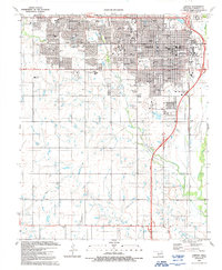 1991 Lawton1991 Print · USGSLawton in the early nineties displays a bustling regional hub defined by expanding medical centers and academic campuses. Researchers can trace the town's evolution through landmarks like Cameron University, the Municipal Airport, and neighborhood schools like Eisenhower School.
 - 1991 Map of Arbuckle Hill
 1991 Arbuckle Hill1991 Print · USGSOklahoma's military heartland is captured here during the late twentieth century, showing the intersection of historic training grounds and local genealogy. Researchers can trace the perimeter of the Fort Sill Military Reservation and locate old burials at Beef Creek Cem or Balitsos South Cem.
 - 1991 Map of Ninemile Creek
 1991 Ninemile Creek1991 Print · USGSEastern Lawton and the surrounding plains show a landscape of suburban growth and utility infrastructure in the early nineties. Genealogists and local historians can trace family-named sites like Flower Mound Cem and early aviation at the R & D Aviation Landing Strip.
 - 1991 Map of Fort Sill
 1991 Fort Sill1991 Print · USGSComanche County and the sprawling Fort Sill military complex appear in detail during the early nineties. Researchers can trace the layout of Fort Sill, find the Comanche Tribal Complex, and locate family sites near Highland Cemetery.
 - 1991 Map of Taupa, 1992 Print
 1991 Taupa1992 Print · USGSComanche County is shown at the start of the nineties as a landscape of established rural communities and small-town growth. Researchers can locate specific family burial sites at Deyo Cem and Pecan Cem or trace the path of the old railroad grade.
 - 1991 Map of Mount Scott, 1992 Print
 1991 Mount Scott1992 Print · USGSComanche County is shown at a time when the peaks of the Wichita Mountains met the expansive training grounds of Fort Sill. Researchers can locate the grounds of The Holy City, trace the streets of Medicine Park, or find family sites near Cache Cemetery and Komah Mem Ch.
 - 1997 Map of Mount Scott, 2000 Print
 1997 Mount Scott2000 Print · USGSComanche County during the late nineties shows a fascinating intersection of military training grounds and wildlife conservation. Genealogists and local historians can trace the area around Cache, the resort streets of Medicine Park, or the grounds of The Holy City.
End of results
Showing maps 1-7 of 7
Top cities near Lawton
- Walters historical maps
- Cache historical maps
- Elgin historical maps
- Geronimo historical maps
- Fletcher historical maps
- Chattanooga historical maps
See more
Top neighborhoods of Lawton
- Dempsey Bridge historical maps
- Pig Farm Crossing historical maps
- White Wolf Bridge historical maps
- Craig Crossing historical maps
- Geronimo Acres historical maps
- Henry Post Manor historical maps
See more
Frequently asked questions
- What are the different types of historical maps available for Lawton?
- What is the oldest map of Lawton?
- Where can I purchase historical maps of Lawton for my home or office?
- Where can I download high-res historical maps of Lawton?
- Are there historical topographic maps available for Lawton?
- Is there historical aerial imagery available for Lawton?
- Where are historical maps of Lawton sourced from?