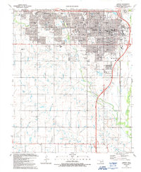
1991 Map of Lawton
USGS Topo · Published 1991About this map
The growing city of Lawton anchors this late 20th-century survey, showcasing a landscape of education, medicine, and transit infrastructure. Cameron University and a dense network of public schools like Eisenhower High School and Tomlinson Junior High School define the northern urban area. The city's medical sector is prominent, with the Comanche County Memorial Hospital and Southwestern Medical Center serving the region.
Find a feature on this map
59 named features on this map. Tap any name to fly to it.
Don’t see what you’re looking for? This feature index may not catch every label — zoom into the map to look around manually.
Map Details
Editions of this 1991 Lawton Map
This is the sole edition of this map. No revisions or reprints were ever made.
Other maps of this area

1937 · Cache
USGS Topo · 1:48,000

1942 · Cache
USGS Topo · 1:62,500

1946 · Lawton
USGS Topo · 1:62,500

1949 · Mount Scott
USGS Topo · 1:24,000

1949 · Arbuckle Hill
USGS Topo · 1:24,000

1949 · Fort Sill
USGS Topo · 1:24,000

1955 · Lawton
USGS Topo · 1:250,000

1956 · Ninemile Creek
USGS Topo · 1:24,000

1956 · Arbuckle Hill
USGS Topo · 1:24,000
1956 · Mount Scott
USGS Topo · 1:24,000