1910s Maps of Creek County, Oklahoma
Explore 5 historic maps of Creek County from the 1910s. These maps offer a rare glimpse into what life looked like during the 1910s — showing old roads, neighborhoods, homes, and landmarks that have changed or disappeared over time.
Whether you're researching your family's past, planning a metal detecting trip, or studying how Creek County's landscape evolved across the 1910s, these high-resolution maps are a powerful tool for exploring the history of this region.
- Focus on a specific era: All maps on this page are from the 1910s, giving you a focused view of this time period.
- See what’s changed: Compare century-old streets, trails, and buildings to today's modern landscape using overlays and satellite layers.
- Research with precision: Use these maps for genealogy, historical research, land use analysis, or educational projects.
- View, download, or print: Maps are fully viewable online in high resolution, and can be downloaded or printed for your own records.
Start exploring Creek County's history through authentic maps from the 1910s. This is your window into the past.
Creek County, OK maps
(5)- 1912 Map of Hominy, 1960 Print
 1912 Hominy1960 Print · USGSNortheastern Oklahoma comes alive in this pre-reservoir survey, documenting the river-valley settlements and tribal lands of the early statehood era. Genealogists can locate dozens of country schools and sites like Black Dog (Indian Village) or the early Oil City Barnsdall P O.
 - 1914 Map of Kiefer
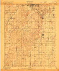
 1914 Kiefer1914 Print · USGSCreek and Tulsa Counties are seen here during the height of the early oil boom, centered on the rail junctions and tank farms. Researchers can trace the development of petroleum infrastructure near Glenpool or locate vanished country schools like Blackout Forest School and Locust Hill School.2 unique versions available
 - 1915 Map of Hominy
 1915 Hominy1915 Print · USGSOsage and Creek counties come to life in the years before the Great War, showing a landscape defined by river confluences and the expansion of the rail industry. Genealogists can locate early settlements like Black Dog and schools like Dripping Spring School or Sunset School.2 unique versions available
 - 1916 Map of Kiefer
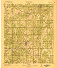
 1916 Kiefer1916 Print · USGSCreek County at the height of the early oil boom years is captured here in fine detail. Genealogists can trace the rural landscape through family-named schools like Crowson School, Bluebell School, and the Louisiana Baptist Church.3 unique versions available
 - 1916 Map of Bristow
 1916 Bristow1916 Print · USGSBristow and its surrounding Creek County townships appear here during the early oil boom years of the mid-1910s. Researchers can locate dozens of country schools and unique landmarks like the Indian Dance Grounds and the industrial Oil Tank Farm.5 unique versions available
End of results
Showing maps 1-5 of 5
Top cities of Creek County
- Sapulpa historical maps
- Bristow historical maps
- Drumright historical maps
- Kiefer historical maps
- Mounds historical maps
- Oilton historical maps
See more
Frequently asked questions
- What are the different types of historical maps available for Creek County?
- What is the oldest map of Creek County?
- Where can I purchase historical maps of Creek County for my home or office?
- Where can I download high-res historical maps of Creek County?
- Are there historical topographic maps available for Creek County?
- Is there historical aerial imagery available for Creek County?
- Where are historical maps of Creek County sourced from?