1950s Maps of Custer County, Oklahoma
Explore 6 historic maps of Custer County from the 1950s. These maps offer a rare glimpse into what life looked like during the 1950s — showing old roads, neighborhoods, homes, and landmarks that have changed or disappeared over time.
Whether you're researching your family's past, planning a metal detecting trip, or studying how Custer County's landscape evolved across the 1950s, these high-resolution maps are a powerful tool for exploring the history of this region.
- Focus on a specific era: All maps on this page are from the 1950s, giving you a focused view of this time period.
- See what’s changed: Compare century-old streets, trails, and buildings to today's modern landscape using overlays and satellite layers.
- Research with precision: Use these maps for genealogy, historical research, land use analysis, or educational projects.
- View, download, or print: Maps are fully viewable online in high resolution, and can be downloaded or printed for your own records.
Start exploring Custer County's history through authentic maps from the 1950s. This is your window into the past.
Custer County, OK maps
(6)- 1955 Map of Clinton, 1964 Print
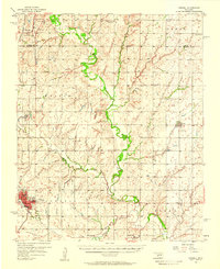
 1955 Clinton1964 Print · USGSWestern Oklahoma during the mid-century transition shows a landscape of growing reservoirs and active military flight lines. Genealogists and historians can locate rural landmarks such as Mountain View Church, Berlin School, and the Riverside Indian School Reserve.3 unique versions available
 - 1956 Map of Cordell, 1958 Print
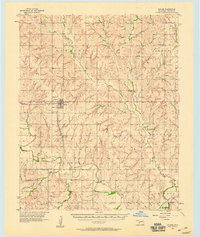
 1956 Cordell1958 Print · USGSWashita County during the mid-fifties reveals a landscape of thriving rail towns and deep-rooted rural congregations. Genealogists can trace family footprints across the St Louis - San Francisco line and through local landmarks like Old Crow Cem or Bessie.2 unique versions available
 - 1957 Map of Clinton
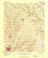
 1957 Clinton1957 Print · USGSWestern Oklahoma in the mid-fifties is captured here as a landscape of river-valley settlements and emerging energy fields. Genealogists can trace family roots through numerous rural landmarks like the Swapping Back Indian School, Hebron Church, and the Riverside Indian School Reserve.
 - 1957 Map of Butler, 1958 Print
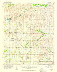
 1957 Butler1958 Print · USGSCuster County in the late fifties shows a rural landscape defined by the Washita River and the Santa Fe railroad. Researchers can trace family history through numerous rural landmarks like Prairie View Ch, Anthon Cem, and the village of Stafford.2 unique versions available
 - 1957 Map of Clinton, 1958 Print
 1957 Clinton1958 Print · USGSCuster County was a thriving network of rail-side towns and rural school districts during the mid-fifties. Genealogists can trace family names through the Masonic Cem and Independence Cem, while collectors can map the route of the St Louis and San Francisco railroad.2 unique versions available
 - 1957 Map of Dill City, 1958 Print
 1957 Dill City1958 Print · USGSWestern Oklahoma during the late fifties centers on the expansive Clinton-Sherman Air Force Base and the crossroads of the Santa Fe and Rock Island railroads. Genealogists can trace family names through dozens of rural sites like Kerns Cem, Novis Cem, and the Parkersburg Sch.3 unique versions available
End of results
Showing maps 1-6 of 6
Top cities of Custer County
- Weatherford historical maps
- Clinton historical maps
- Thomas historical maps
- Arapaho historical maps
- Custer City historical maps
- Butler historical maps
Frequently asked questions
- What are the different types of historical maps available for Custer County?
- What is the oldest map of Custer County?
- Where can I purchase historical maps of Custer County for my home or office?
- Where can I download high-res historical maps of Custer County?
- Are there historical topographic maps available for Custer County?
- Is there historical aerial imagery available for Custer County?
- Where are historical maps of Custer County sourced from?