1970s Maps of Custer County, Oklahoma
Explore 9 historic maps of Custer County from the 1970s. These maps offer a rare glimpse into what life looked like during the 1970s — showing old roads, neighborhoods, homes, and landmarks that have changed or disappeared over time.
Whether you're researching your family's past, planning a metal detecting trip, or studying how Custer County's landscape evolved across the 1970s, these high-resolution maps are a powerful tool for exploring the history of this region.
- Focus on a specific era: All maps on this page are from the 1970s, giving you a focused view of this time period.
- See what’s changed: Compare century-old streets, trails, and buildings to today's modern landscape using overlays and satellite layers.
- Research with precision: Use these maps for genealogy, historical research, land use analysis, or educational projects.
- View, download, or print: Maps are fully viewable online in high resolution, and can be downloaded or printed for your own records.
Start exploring Custer County's history through authentic maps from the 1970s. This is your window into the past.
Custer County, OK maps
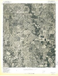
(9)- 1976 Map of Clinton SE
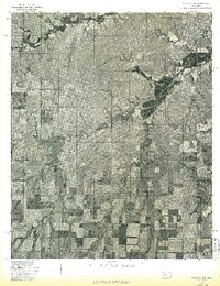
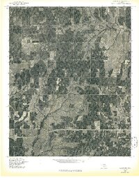 1976 Clinton SE1976 Print · USGSCuster County agricultural patterns and rural crossroads are captured in this mid-seventies aerial survey. Local historians can trace the course of Bear Creek and the small settlement of Indianapolis through high-resolution photographic detail.
 - 1976 Map of Butler NW
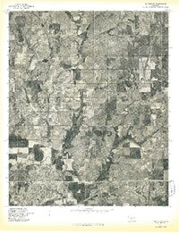
 1976 Butler NW1976 Print · USGSCuster County agricultural patterns are captured in detail in the mid-seventies, showing the prairie landscape north of Butler. Researchers can trace the path of West Barnitz Creek and the intricate grid of section-line roads and farmsteads.
 - 1976 Map of Butler NE
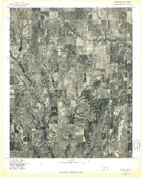
 1976 Butler NE1976 Print · USGSCuster County land patterns are captured in the mid-1970s through this detailed orthophoto study of central Oklahoma. Researchers can examine the natural drainage and land use along East Barnitz Creek and West Barnitz Creek.
 - 1976 Map of Butler SW
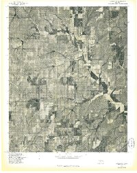
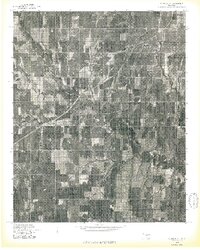
 1976 Butler SW1976 Print · USGSCuster County land and water patterns are captured here in the mid-1970s, showcasing the development of the region's water infrastructure. Trace the early shoreline of Foss Reservoir and the winding course of the Washita River across the plains.
 - 1976 Map of Dill City NE
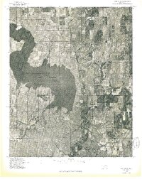
 1976 Dill City NE1976 Print · USGSWashita County in the mid-seventies shows a landscape defined by agricultural precision and significant water infrastructure. You can trace the winding path of Turkey Creek as it feeds into Clinton Lake and locate the settlement of Foss.
 - 1976 Map of Clinton SW
 1976 Clinton SW1976 Print · USGSCuster County comes into sharp focus during the mid-seventies in this detailed aerial study of the Oklahoma prairie. You can trace the winding Washita River and the 1970s boundaries of Clinton and Arapaho during a period of agricultural growth.
 - 1976 Map of Clinton NW
 1976 Clinton NW1976 Print · USGSCuster County land patterns and rural crossroads are captured in detail during the mid-seventies. Local historians can trace the street layouts of Custer City or examine the agricultural developments surrounding Independence.
 - 1976 Map of Clinton NE
 1976 Clinton NE1976 Print · USGSCuster County agricultural lands are captured in this mid-seventies aerial survey, showing the rural grid system and winding watercourses. Researchers can identify farmstead layouts near Thomas, the location of Foley, and the drainage of Deer Creek.
 - 1976 Map of Butler SE
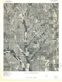
 1976 Butler SE1976 Print · USGSCuster County in the mid-seventies is captured in this aerial survey of its farming heartland and river bottoms. Genealogists and local historians can trace the rural landscape around Stafford and Ralph along the Washita River.
End of results
Showing maps 1-9 of 9
Top cities of Custer County
- Weatherford historical maps
- Clinton historical maps
- Thomas historical maps
- Arapaho historical maps
- Custer City historical maps
- Butler historical maps
Frequently asked questions
- What are the different types of historical maps available for Custer County?
- What is the oldest map of Custer County?
- Where can I purchase historical maps of Custer County for my home or office?
- Where can I download high-res historical maps of Custer County?
- Are there historical topographic maps available for Custer County?
- Is there historical aerial imagery available for Custer County?
- Where are historical maps of Custer County sourced from?