1960s Maps of Delaware County, Oklahoma
Explore 5 historic maps of Delaware County from the 1960s. These maps offer a rare glimpse into what life looked like during the 1960s — showing old roads, neighborhoods, homes, and landmarks that have changed or disappeared over time.
Whether you're researching your family's past, planning a metal detecting trip, or studying how Delaware County's landscape evolved across the 1960s, these high-resolution maps are a powerful tool for exploring the history of this region.
- Focus on a specific era: All maps on this page are from the 1960s, giving you a focused view of this time period.
- See what’s changed: Compare century-old streets, trails, and buildings to today's modern landscape using overlays and satellite layers.
- Research with precision: Use these maps for genealogy, historical research, land use analysis, or educational projects.
- View, download, or print: Maps are fully viewable online in high resolution, and can be downloaded or printed for your own records.
Start exploring Delaware County's history through authentic maps from the 1960s. This is your window into the past.
Delaware County, OK maps
(5)- 1963 Map of Tulsa
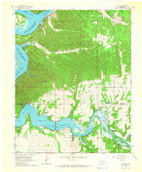
 1963 Tulsa1963 Print · USGSThe Oklahoma and Arkansas borderlands are shown here in the early sixties, a time of massive reservoir construction and heavy mining. Genealogists can trace family roots through settlements like Nowata, Pryor, and Jay, or locate historical zinc and lead mines and coal mines.
 - 1964 Map of Cayuga, 1966 Print
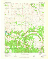
 1964 Cayuga1966 Print · USGSDelaware and Ottawa Counties in the mid-1960s show a landscape shaped by the waters of the Neosho and Elk Rivers. Genealogists and historians can trace rural life through the Indian Ceremonial Grounds, Turkey Ford School, and Howard Cemetery.2 unique versions available
 - 1964 Map of Dodge, 1966 Print
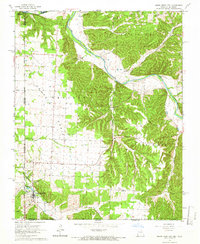
 1964 Dodge1966 Print · USGSThe rolling lands of Cow Skin Prairie and the shores of Lake O' the Cherokees appear here in the mid-1960s. Genealogists can trace local roots through numerous sites like Olympus Cem, Dodge Ch, and Pollan Cem.2 unique versions available
 - 1965 Map of South West City, 1966 Print
 1965 South West City1966 Print · USGSThe tri-state border region of Missouri, Oklahoma, and Arkansas was a landscape of quiet prairie and river bluffs during the mid-sixties. Researchers can locate numerous family burial sites and rural congregations, from Williams-Hays Cem to Liberty Ch near South West City.
 - 1965 Map of Tiff City, 1966 Print
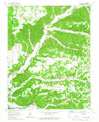 1965 Tiff City1966 Print · USGSMissouri and Oklahoma meet along these river valleys in the mid-1960s, a period of quiet rural life defined by small hill communities. Genealogists can locate family landmarks such as Keenon Cem, Hart Sch, and the Council House Indian Reservation.3 unique versions available
End of results
Showing maps 1-5 of 5
Top cities of Delaware County
- Grove historical maps
- Jay historical maps
- West Siloam Springs historical maps
- Colcord historical maps
- Kansas historical maps
- Bernice historical maps
Frequently asked questions
- What are the different types of historical maps available for Delaware County?
- What is the oldest map of Delaware County?
- Where can I purchase historical maps of Delaware County for my home or office?
- Where can I download high-res historical maps of Delaware County?
- Are there historical topographic maps available for Delaware County?
- Is there historical aerial imagery available for Delaware County?
- Where are historical maps of Delaware County sourced from?