1940s Maps of Grady County, Oklahoma
Explore 4 historic maps of Grady County from the 1940s. These maps offer a rare glimpse into what life looked like during the 1940s — showing old roads, neighborhoods, homes, and landmarks that have changed or disappeared over time.
Whether you're researching your family's past, planning a metal detecting trip, or studying how Grady County's landscape evolved across the 1940s, these high-resolution maps are a powerful tool for exploring the history of this region.
- Focus on a specific era: All maps on this page are from the 1940s, giving you a focused view of this time period.
- See what’s changed: Compare century-old streets, trails, and buildings to today's modern landscape using overlays and satellite layers.
- Research with precision: Use these maps for genealogy, historical research, land use analysis, or educational projects.
- View, download, or print: Maps are fully viewable online in high resolution, and can be downloaded or printed for your own records.
Start exploring Grady County's history through authentic maps from the 1940s. This is your window into the past.
Grady County, OK maps
(4)- 1945 Map of Anadarko
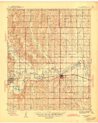 1945 Anadarko1945 Print · USGSCaddo and Grady counties are documented during the mid-1940s as the rail-and-river economy flourished. Genealogists can locate numerous rural community landmarks like Liberty Cem, Riverside Indian School, and Oakdale Sch.2 unique versions available
 - 1949 Map of Cement, 1953 Print
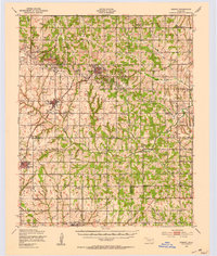 1949 Cement1953 Print · USGSThe oil-and-rail economy of Caddo and Comanche counties is on full display here in the late forties. Researchers can locate dozens of country schools like Highview Sch and Rocky Ford Sch or trace the industrial footprint of the Oil Refinery at Cyril.
 - 1949 Map of Nellie, 1953 Print
 1949 Nellie1953 Print · USGSThe Oklahoma plains around the Comanche and Stephens county lines come alive in this post-war survey. Researchers can trace the social fabric of rural life through numerous country schools and churches, including Starr Sch, Nellie, and the Rock Creek Cem.2 unique versions available
 - 1949 Map of Rush Springs, 1964 Print
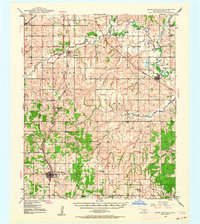 1949 Rush Springs1964 Print · USGSGrady County at mid-century reveals a landscape defined by the Washita River valley and the reach of the Rock Island railroad. Genealogists can trace family roots through numerous rural landmarks like Vimy Ridge Sch, Morris Cem, and the settlement of Ninnekah.2 unique versions available
End of results
Showing maps 1-4 of 4
Top cities of Grady County
- Chickasha historical maps
- Tuttle historical maps
- Minco historical maps
- Rush Springs historical maps
- Ninnekah historical maps
- Verden historical maps
See more
Frequently asked questions
- What are the different types of historical maps available for Grady County?
- What is the oldest map of Grady County?
- Where can I purchase historical maps of Grady County for my home or office?
- Where can I download high-res historical maps of Grady County?
- Are there historical topographic maps available for Grady County?
- Is there historical aerial imagery available for Grady County?
- Where are historical maps of Grady County sourced from?