1980s Maps of Grady County, Oklahoma
Explore 10 historic maps of Grady County from the 1980s. These maps offer a rare glimpse into what life looked like during the 1980s — showing old roads, neighborhoods, homes, and landmarks that have changed or disappeared over time.
Whether you're researching your family's past, planning a metal detecting trip, or studying how Grady County's landscape evolved across the 1980s, these high-resolution maps are a powerful tool for exploring the history of this region.
- Focus on a specific era: All maps on this page are from the 1980s, giving you a focused view of this time period.
- See what’s changed: Compare century-old streets, trails, and buildings to today's modern landscape using overlays and satellite layers.
- Research with precision: Use these maps for genealogy, historical research, land use analysis, or educational projects.
- View, download, or print: Maps are fully viewable online in high resolution, and can be downloaded or printed for your own records.
Start exploring Grady County's history through authentic maps from the 1980s. This is your window into the past.
Grady County, OK maps
(10)- 1981 Map of Lawton
 1981 Lawton1981 Print · USGSSouthwestern Oklahoma in the early eighties shows a landscape shaped by military history and the rising peaks of the Wichitas. Researchers can trace the boundaries of the Fort Sill Military Reservation and locate early settlements like Meers, Chattanooga, and Richards Spur.
 - 1981 Map of Marlow
 1981 Marlow1981 Print · USGSMarlow and the surrounding Stephens County oil fields are captured here in the early eighties. Genealogists and local historians can trace the town’s layout from Marlow Cem to residential streets like Caddo Ave and landmarks such as the Armory.
 - 1981 Map of East Roaring Creek, 1982 Print
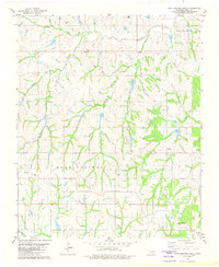 1981 East Roaring Creek1982 Print · USGSGrady County in the early eighties shows a landscape shaped by petroleum production and deep-rooted rural communities. Trace the energy infrastructure near Chitwood or locate local landmarks like Vimy Ridge Ch and the Refinery.
 - 1981 Map of Rush Springs, 1982 Print
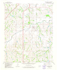
 1981 Rush Springs1982 Print · USGSOklahoma's Grady County comes into focus in the early eighties, centered on the vital water sources and tribal lands of the southern plains. Trace historical land divisions along the Old Indian Territory Boundary or locate local landmarks like Carter Spr and the Cem near Rush Springs.
 - 1981 Map of East Ninnekah, 1982 Print
 1981 East Ninnekah1982 Print · USGSGrady County's landscape in the early eighties reveals a unique intersection of modern infrastructure and territorial history. Genealogists and local historians can trace the Indian Territory Oklahoma Boundary past Moncrief Cem and the small settlement of Agawam.
 - 1981 Map of Alex, 1982 Print
 1981 Alex1982 Print · USGSGrady County during the early eighties showcases a landscape defined by the winding Washita River and the rural community of Alex. Researchers can locate family landmarks such as Hawkins Ch, Ireton Cem, and the long-retired Old Railroad Grade.
 - 1982 Map of Bray
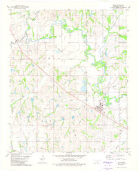
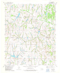 1982 Bray1982 Print · USGSThe rural border of Grady and Stephens counties is captured in the early eighties as a landscape of creeks and energy production. Genealogists and local historians can locate the Bray Church, the town of Bailey, and the community of Wall near Rush Creek.
 - 1985 Map of Oklahoma City South
 1985 Oklahoma City South1985 Print · USGSOklahoma City and its southern neighbors show a period of significant growth during the mid-eighties as suburban expansion met rural county lines. Researchers can trace the development of Tinker Air Force Base and locate smaller communities like Goldsby, Stella, and Woody Chapel.2 unique versions available
 - 1986 Map of Anadarko
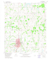
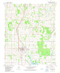
 1986 Anadarko1986 Print · USGSThe Oklahoma plains around Anadarko are captured in the mid-1980s, showing the intersection of rail history and tribal heritage. Genealogists and historians can trace the Indian Treaty Boundary or locate old rail stops along the Burlington Northern Railroad and Atchison, Topeka and Santa Fe Railway.2 unique versions available
 - 1986 Map of Pauls Valley
 1986 Pauls Valley1986 Print · USGSGarvin County and its neighbors are shown in the mid-1980s during a period of steady growth along the Washita River. Researchers can trace the path of the Atchison Topeka and Santa Fe railroad through Pauls Valley or locate rural sites like Mt Olive Church and Erin Springs.2 unique versions available
End of results
Showing maps 1-10 of 10
Top cities of Grady County
- Chickasha historical maps
- Tuttle historical maps
- Minco historical maps
- Rush Springs historical maps
- Ninnekah historical maps
- Verden historical maps
See more
Frequently asked questions
- What are the different types of historical maps available for Grady County?
- What is the oldest map of Grady County?
- Where can I purchase historical maps of Grady County for my home or office?
- Where can I download high-res historical maps of Grady County?
- Are there historical topographic maps available for Grady County?
- Is there historical aerial imagery available for Grady County?
- Where are historical maps of Grady County sourced from?