1970s Maps of Hughes County, Oklahoma
Explore 11 historic maps of Hughes County from the 1970s. These maps offer a rare glimpse into what life looked like during the 1970s — showing old roads, neighborhoods, homes, and landmarks that have changed or disappeared over time.
Whether you're researching your family's past, planning a metal detecting trip, or studying how Hughes County's landscape evolved across the 1970s, these high-resolution maps are a powerful tool for exploring the history of this region.
- Focus on a specific era: All maps on this page are from the 1970s, giving you a focused view of this time period.
- See what’s changed: Compare century-old streets, trails, and buildings to today's modern landscape using overlays and satellite layers.
- Research with precision: Use these maps for genealogy, historical research, land use analysis, or educational projects.
- View, download, or print: Maps are fully viewable online in high resolution, and can be downloaded or printed for your own records.
Start exploring Hughes County's history through authentic maps from the 1970s. This is your window into the past.
Hughes County, OK maps
(11)- 1970 Map of Lamar, 1972 Print
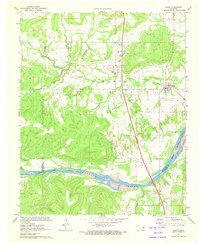
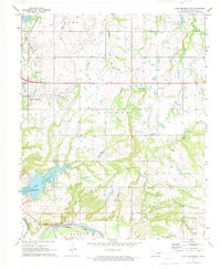
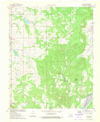 1970 Lamar1972 Print · USGSHughes County in the early seventies shows a landscape where traditional rural settlements meet an active energy industry. Researchers can trace the Missouri Pacific rail corridor through Lamar, find local landmarks like the Moss Sch, or locate family sites at the Mc Mahan Cem.
 - 1971 Map of Wetumka SE, 1972 Print
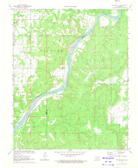 1971 Wetumka SE1972 Print · USGSThe Canadian River valley in the early seventies reveals a landscape defined by its waterways and regional energy production. Genealogists and local historians can trace family landmarks like the Tulmochasse Ch, Lamar Cem, and the tracks of the Missouri Pacific railroad.
 - 1971 Map of Wetumka, 1973 Print
 1971 Wetumka1973 Print · USGSWetumka and the surrounding Hughes County countryside are shown here in the early 1970s, characterized by a mix of rail transit and active energy extraction. Genealogists and local historians can locate family landmarks like Barnett Cem or trace the ST L-S F railroad.2 unique versions available
 - 1971 Map of Carson, 1973 Print
 1971 Carson1973 Print · USGSThe rural landscape of Hughes County is captured here in the early 1970s, showcasing the intersection of the regional energy industry and rail transport. Researchers can trace the path of the Texas and Pacific railroad near Carson or locate numerous Oil Wells and a Pumping Station across the hills.2 unique versions available
 - 1971 Map of Hanna, 1973 Print
 1971 Hanna1973 Print · USGSMcIntosh and Hughes counties are captured here in the early seventies as the local landscape adapted to the new Eufaula Reservoir. Researchers can trace family history at the Vernon Cem or locate rural landmarks like Weogufkee Ch and the Old Railroad Grade.2 unique versions available
 - 1972 Map of Wewoka East, 1974 Print
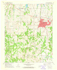
 1972 Wewoka East1974 Print · USGSOklahoma's oil-rich countryside comes into focus during the early seventies, centered on the growing county seat and its rail connections. Researchers can trace the layout of Wewoka, find rural landmarks like Pilgrims Rest Ch, or locate family sites near Oakwood Cem.
 - 1972 Map of Yeager, 1974 Print
 1972 Yeager1974 Print · USGSCentral Oklahoma's oil fields and rural townships are captured in the early seventies, centered on the community of Yeager. Genealogists and historians can trace family sites like Wisner Cem and several local churches along the St Louis-San Francisco rail line.
 - 1972 Map of Holdenville, 1974 Print
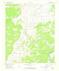
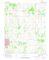
 1972 Holdenville1974 Print · USGSHoldenville and the surrounding Oklahoma oil fields are captured in detail during the early seventies. Genealogists and historians can trace family sites at Buchner Memorial Cemetery, local schools like Thomas School, and industrial landmarks across the Jacobs Oil Field.
 - 1972 Map of Lake Holdenville, 1974 Print
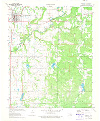
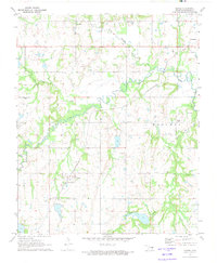
 1972 Lake Holdenville1974 Print · USGSIn the early 1970s, Hughes County saw a landscape defined by the Canadian River and a booming petroleum industry. Family historians can trace rural roots at Glory Cem or follow the legacy of local congregations like Hulsey Ch and Hickory Grove Ch.2 unique versions available
 - 1978 Map of Eufaula, 1979 Print
 1978 Eufaula1979 Print · USGSEastern Oklahoma in the late seventies is defined by the sprawling waters of Eufaula Lake and the dense timber of the Sans Bois Mountains. Genealogists and historians can trace the development of towns like Checotah and Stigler or locate legacy sites like the Old R R Grade and Robbers Cave State Park.
 - 1978 Map of Fort Smith, 1979 Print
 1978 Fort Smith1979 Print · USGSThe Arkansas-Oklahoma borderlands in the late seventies show a landscape shaped by massive river reservoirs and sprawling military reservations. Trace the historic rail lines of the Missouri Pacific RR and locate regional landmarks like Fort Gibson, Tenkiller Ferry Lake, and Barling.2 unique versions available
End of results
Showing maps 1-11 of 11
Top cities of Hughes County
- Holdenville historical maps
- Wetumka historical maps
- Dustin historical maps
- Calvin historical maps
- Stuart historical maps
- Lamar historical maps
See more
Frequently asked questions
- What are the different types of historical maps available for Hughes County?
- What is the oldest map of Hughes County?
- Where can I purchase historical maps of Hughes County for my home or office?
- Where can I download high-res historical maps of Hughes County?
- Are there historical topographic maps available for Hughes County?
- Is there historical aerial imagery available for Hughes County?
- Where are historical maps of Hughes County sourced from?