Old Maps of Kay County, Oklahoma for Genealogy
Trace your family roots with 138 historic maps of Kay County. These high-res maps reveal old neighborhoods, homesites, landmarks, and streets — helping you uncover where your ancestors lived and how the area evolved over time.
- Explore historic neighborhoods: Identify where your relatives may have lived in the 1800s or 1900s.
- Compare maps over time: Trace the changes in streets, buildings, and landmarks for multi-generational research.
- Perfect for genealogy & ancestry research: Used by family historians and researchers to map out lineage and migration.
These maps are an incredible resource for exploring your personal connection to Kay County's past.
Kay County, OK maps
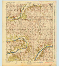
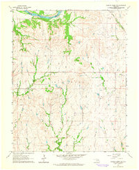
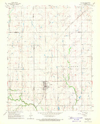
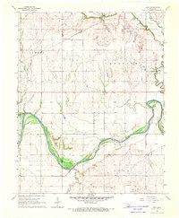
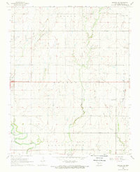
(138)- 1935 Map of Kaw
 1935 Kaw1935 Print · USGSNorthern Oklahoma's river valleys and rural school districts are captured here in the mid-1930s as the Santa Fe railroad shaped the local economy. Researchers can trace vanished rural hubs and landmarks like Chilocco, Maple Grove Ch, and Uncas.2 unique versions available
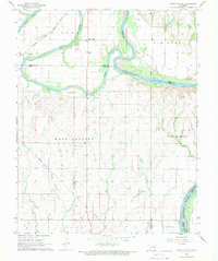
 - 1936 Map of Belford
 1936 Belford1936 Print · USGSOsage and Noble counties come into focus in the mid-1930s, showing a rural landscape defined by the winding Arkansas River. Genealogists and local historians can trace numerous country school sites like Braden Sch and Pleasant Valley Sch, alongside the Atchison Topeka and Santa Fe Ry through Apperson.3 unique versions available
 - 1955 Map of Enid, 1966 Print
 1955 Enid1966 Print · USGSNorth-central Oklahoma's transition from open plains to the blackjack hills of the Osage Indian Reservation is captured in the mid-1950s. Researchers can trace the development of the Naval Reserve Oil Field, the grounds of Vance AFB, and the early footprints of Tulsa and Stillwater.4 unique versions available
 - 1958 Map of Enid
 1958 Enid1958 Print · USGSNorthern Oklahoma is mapped here in the late fifties, showcasing a dense network of petroleum production and historic tribal lands. Researchers can trace the legacy of the Osage Indian Reservation, early energy hubs like the Cushing Oil Field, and the Chilocco Indian Agricultural School.2 unique versions available
 - 1963 Map of Charley Creek, 1964 Print
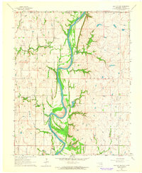
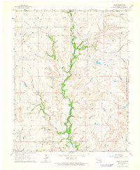
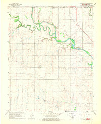
 1963 Charley Creek1964 Print · USGSThe Arkansas River defines the border of Kay and Osage counties in the early 1960s, a landscape shaped by petroleum and rural community life. Researchers can trace family roots at Longwood Ch, Braden Sch, and the Big Bend Oil Field.4 unique versions available
 - 1963 Map of Uncas, 1965 Print
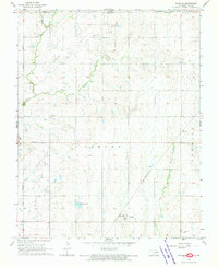
 1963 Uncas1965 Print · USGSThe Arkansas River valley in Kay County shows a landscape of rail-served settlements and early energy production in the early sixties. Trace the path of the Atchison Topeka and Santa Fe through Uncas and locate historical Oil Wells and the Oak Grove Cem.2 unique versions available
 - 1963 Map of Kaw City NW, 1965 Print
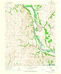
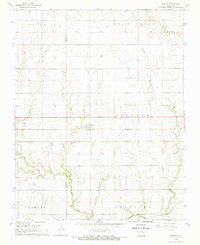
 1963 Kaw City NW1965 Print · USGSThe Oklahoma-Kansas borderlands in the early 1960s were defined by the winding Arkansas River and a network of rural community hubs. Researchers can locate vanished landmarks like Tipton Community Hall, School No 106, and the family history preserved at Cooper Cem.
 - 1964 Map of Charley Creek NE
 1964 Charley Creek NE1964 Print · USGSOsage County's landscape in the 1960s was defined by the oil industry and the winding Arkansas River. Researchers can trace the rail-and-river economy through the settlement of Apperson and the many Oil Wells dotting the Big Hill region.2 unique versions available
 - 1964 Map of Kaw City, 1965 Print
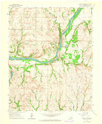
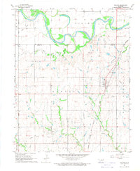
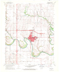
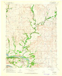 1964 Kaw City1965 Print · USGSKaw City and the Arkansas River valley are shown here in the mid-sixties, just before the landscape was transformed by reservoir construction. Genealogists and local historians can trace the original townsite of Kaw City, the community of Washunga, and the Washunga Cem before their relocation.4 unique versions available
 - 1964 Map of Hardy, 1965 Print
 1964 Hardy1965 Print · USGSNorthern Oklahoma and the Kansas borderlands appear in the mid-sixties as a landscape of rural creek valleys and reservation boundaries. Researchers can trace the Midland Valley terrain and locate local landmarks like the Hardy settlement and the Radio Tower.2 unique versions available
 - 1967 Map of Braman, 1970 Print
 1967 Braman1970 Print · USGSBraman and its surrounding oil fields are captured in the late sixties at the intersection of traditional rail and new interstate travel. Genealogists and local historians can trace the Braman Cem, the rural settlement of Sumpter, and the course of the Chikaskia River.2 unique versions available
 - 1968 Map of Billings, 1969 Print
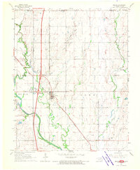
 1968 Billings1969 Print · USGSThe town of Billings and the surrounding plains of Noble and Garfield Counties are captured here in the late sixties. Researchers can trace the diagonal route of the Chicago Rock Island and Pacific railroad and locate local landmarks like Sacred Heart Cem and Billings Union Cem.2 unique versions available
 - 1968 Map of Tonkawa SE, 1969 Print
 1968 Tonkawa SE1969 Print · USGSThe Oklahoma plains in the late sixties reveal an era of intensive energy extraction and expanding highways. Family historians can trace the Three Sands Oil Field and Glenrose while locating rural landmarks like Freedom Ch and Prairie View Cem.2 unique versions available
 - 1968 Map of Marland, 1969 Print
 1968 Marland1969 Print · USGSMarland and the Kay and Noble County line are captured here in the late sixties as the local economy balanced ranching with a maturing oil industry. Researchers can locate the site of Old Bliss, trace the Atchison Topeka and Santa Fe rail line, and find family markers at Cowboy Hill Cem.2 unique versions available
 - 1968 Map of Ponca City NW, 1969 Print
 1968 Ponca City NW1969 Print · USGSThe Kay County landscape during the late sixties is defined by a heavy rail presence and burgeoning oil production near the Arkansas River. Genealogists and historians can trace the foundations of rural Oklahoma through sites like Autwine, Union Sch, and the Round Grove Cem.2 unique versions available
 - 1968 Map of Eddy, 1969 Print
 1968 Eddy1969 Print · USGSNorth Central Oklahoma's river bottomlands are captured here in the late sixties at the junction of the Arkansas River and Salt Fork. Local historians can trace the St Louis-San Francisco rail line through Eddy or locate the New Home Cem.
 - 1968 Map of Ponca City SE, 1969 Print
 1968 Ponca City SE1969 Print · USGSThe confluence of the Salt Fork and Arkansas rivers defines this part of Noble County in the late sixties. Researchers can trace the Atchison Topeka and Santa Fe rail line and locate old community hubs like White Eagle and West Bressie.
 - 1968 Map of Newkirk, 1970 Print
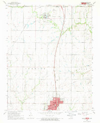 1968 Newkirk1970 Print · USGSKay County at the close of the 1960s shows a landscape defined by the state border and heavy rail infrastructure. Genealogists can trace family footprints at Newkirk Cemetery, the Home for the Aged, and the extensive Chilocco Indian School campus.2 unique versions available
 - 1968 Map of Blackwell NW, 1970 Print
 1968 Blackwell NW1970 Print · USGSThe Oklahoma-Kansas borderlands are captured here in the late sixties, where the Chikaskia River winds through the northern prairie. Researchers can trace rural genealogy and industry through sites like Triumph Cem, the Asbury Ch, and the extensive Webb North Oil Field.2 unique versions available
 - 1968 Map of Nardin, 1970 Print
 1968 Nardin1970 Print · USGSThe northern Oklahoma prairie comes into focus in the late sixties as a crossroads of the energy industry and heavy rail. Genealogists and historians can trace the Atchison Topeka and Santa Fe through Nardin or locate the Mt Oliver Cem.
 - 1968 Map of Tonkawa, 1970 Print
 1968 Tonkawa1970 Print · USGSKay County near the confluence of the Arkansas and Chikaskia Rivers reflects an era of petroleum wealth and collegiate growth. Researchers can trace the legacy of the Tonkawa Oil Field and Hubbard Oil Field alongside the Northern Oklahoma Jr College campus and IOOF Cem.2 unique versions available
 - 1968 Map of Kildare, 1970 Print
 1968 Kildare1970 Print · USGSKay County in the late sixties reveals a landscape shaped by petroleum production and the rail corridor. Researchers can trace the Northwest Kildare Oil and Gas Field and locate landmarks like Pleasant View Sch and Wolf Creek Cem.2 unique versions available
 - 1968 Map of Blackwell, 1970 Print
 1968 Blackwell1970 Print · USGSBlackwell is captured in the late sixties at a peak of industrial and transit growth. Genealogists and historians can trace local landmarks like the IOOF Cemetery, the New Bethel Sch, and the extensive Blackwell Oil and Gas Field.2 unique versions available
 - 1968 Map of Newkirk SW, 1970 Print
 1968 Newkirk SW1970 Print · USGSKay County at the end of the sixties shows a landscape defined by intensive energy extraction and traditional farming communities. Genealogists and historians can locate the St Louis-San Francisco rail line, the settlement of Grainville, and rural landmarks like Prairie Chapel Sch and St Johns Cem.
 - 1968 Map of Peckham, 1970 Print
 1968 Peckham1970 Print · USGSThe Kay County borderlands at the end of the sixties reveal a landscape shaped by petroleum and rail. Researchers can trace the Murphy Oil Field, locate the Church of God, and follow the St Louis - San Francisco line through Peckham.
Showing maps 1-25 of 138
Top cities of Kay County
- Ponca City historical maps
- Blackwell historical maps
- Tonkawa historical maps
- Newkirk historical maps
- Kaw City historical maps
- Braman historical maps
See more
Frequently asked questions
- What are the different types of historical maps available for Kay County?
- What is the oldest map of Kay County?
- Where can I purchase historical maps of Kay County for my home or office?
- Where can I download high-res historical maps of Kay County?
- Are there historical topographic maps available for Kay County?
- Is there historical aerial imagery available for Kay County?
- Where are historical maps of Kay County sourced from?