1900-1909 Maps of Latimer County, Oklahoma
Explore 10 historic maps of Latimer County from 1900-1909. These maps offer a rare glimpse into what life looked like during the 1900s — showing old roads, neighborhoods, homes, and landmarks that have changed or disappeared over time.
Whether you're researching your family's past, planning a metal detecting trip, or studying how Latimer County's landscape evolved across the 1900s, these high-resolution maps are a powerful tool for exploring the history of this region.
- Focus on a specific era: All maps on this page are from the 1900s, giving you a focused view of this time period.
- See what’s changed: Compare century-old streets, trails, and buildings to today's modern landscape using overlays and satellite layers.
- Research with precision: Use these maps for genealogy, historical research, land use analysis, or educational projects.
- View, download, or print: Maps are fully viewable online in high resolution, and can be downloaded or printed for your own records.
Start exploring Latimer County's history through authentic maps from the 1900s. This is your window into the past.
Latimer County, OK maps
(10)- 1900 Map of Sansbois
 1900 Sansbois1900 Print · USGSIndian Territory in the late nineteenth century is documented here through its tribal boundaries and early river settlements. Genealogists can trace family roots near Stigler, Porum, and Whitefield, or locate the isolated station at Sandtown along the St L & S F R R.2 unique versions available
 - 1900 Map of Canadian
 1900 Canadian1900 Print · USGSIndian Territory at the turn of the century shows a landscape of tribal nations and developing rail towns along the CANADIAN RIVER. Genealogists and historians can trace early settlements like Fishertown and Indianola or the original Creek Nation Choctaw Nation Boundary Line.6 unique versions available
 - 1900 Map of Sallisaw
 1900 Sallisaw1900 Print · USGSThe Cherokee and Choctaw Nations are divided by the winding Arkansas River at the turn of the century. Genealogists can trace early tribal-era settlements like Bokoshe, Tamaha, and Oak Lodge along the routes of the Kansas City Southern R. R.2 unique versions available
 - 1900 Map of Winding Stair
 1900 Winding Stair1900 Print · USGSThe Choctaw Nation at the turn of the century shows a frontier landscape shaped by the Ouachita Mountains and new rail lines. Genealogists can locate early settlements like Summerfield and Heavener or trace the Woods Trail across the Kiamichi Mountain range.2 unique versions available
 - 1901 Map of Tuskahoma
 1901 Tuskahoma1901 Print · USGSThe Choctaw Nation in the Indian Territory is captured here during its transition to statehood, showing a landscape of tribal centers and early railroad expansion. Genealogists and historians can locate the Council House and rural outposts like Bengal, Ola, and Damon.
 - 1908 Map of Tuskahoma, 1964 Print
 1908 Tuskahoma1964 Print · USGSOklahoma's Choctaw Nation territory at the start of the twentieth century shows a landscape shaped by ridge-top boundaries and the arrival of the steam engine. Researchers can locate early landmarks like the Choctaw Council House, Peachland Chapel, and mining era towns like Wilburton.
 - 1909 Map of Mc Alester
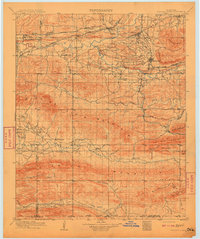
 1909 Mc Alester1909 Print · USGSSoutheast Oklahoma's coal mining belt and the rugged Choctaw Nation territory are captured here in the early years of statehood. Researchers can trace the rail-side growth of McAlester and Hartshorne or locate vanished sites like Barnett Sta Haywood PO and Perryville.3 unique versions available
 - 1909 Map of Tuskahoma
 1909 Tuskahoma1909 Print · USGSSoutheastern Oklahoma’s rugged mountain corridors and Choctaw Nation landmarks are documented here at the end of the territorial era. Genealogists and historians can trace rail-town development and find remote sites like the Choctaw Council House, Bunchtown, and Thessalonica Church.3 unique versions available
 - 1909 Map of Winding Stair
 1909 Winding Stair1909 Print · USGSSoutheastern Oklahoma’s early statehood era is defined here by the intersection of major rail corridors and high mountain ridges. Researchers can trace the development of transit hubs like Heavener and Wister, or locate remote valley settlements such as Whitesboro and Muse.4 unique versions available
 - 1909 Map of Sans Bois, 1954 Print
 1909 Sans Bois1954 Print · USGSHaskell and Muskogee counties are seen here in the decade following statehood, when rail lines and river crossings dictated the pulse of rural life. Genealogists can trace family roots through numerous local landmarks like Kanima P O, Belle Starr School, and the Sansbois Sta.
End of results
Showing maps 1-10 of 10
Top cities of Latimer County
Frequently asked questions
- What are the different types of historical maps available for Latimer County?
- What is the oldest map of Latimer County?
- Where can I purchase historical maps of Latimer County for my home or office?
- Where can I download high-res historical maps of Latimer County?
- Are there historical topographic maps available for Latimer County?
- Is there historical aerial imagery available for Latimer County?
- Where are historical maps of Latimer County sourced from?