1960s Maps of Poteau, Oklahoma
Explore 8 historic maps of Poteau from the 1960s. These maps offer a rare glimpse into what life looked like during the 1960s — showing old roads, neighborhoods, homes, and landmarks that have changed or disappeared over time.
Whether you're researching your family's past, planning a metal detecting trip, or studying how Poteau's landscape evolved across the 1960s, these high-resolution maps are a powerful tool for exploring the history of this region.
- Focus on a specific era: All maps on this page are from the 1960s, giving you a focused view of this time period.
- See what’s changed: Compare century-old streets, trails, and buildings to today's modern landscape using overlays and satellite layers.
- Research with precision: Use these maps for genealogy, historical research, land use analysis, or educational projects.
- View, download, or print: Maps are fully viewable online in high resolution, and can be downloaded or printed for your own records.
Start exploring Poteau's history through authentic maps from the 1960s. This is your window into the past.
Poteau, OK maps
(8)- 1962 Map of McAlester
 1962 McAlester1962 Print · USGSSoutheastern Oklahoma and western Arkansas are shown here during the early sixties, a time of transition for the region's mountain communities and timberlands. Researchers can trace the paths of the Kansas City Southern RR through Heavener or locate settlements like Talihina and Broken Bow near the Kiamichi Mountains.2 unique versions available
 - 1965 Map of Fort Smith
 1965 Fort Smith1965 Print · USGSEastern Oklahoma and Western Arkansas are captured here during a period of massive post-war change as new reservoirs reshaped the river valleys. Genealogists and historians can trace the rail networks of the Midland Valley RR and find established communities like Stilwell, Sallisaw, and Stigler.
 - 1965 Map of McAlester
 1965 McAlester1965 Print · USGSSoutheastern Oklahoma and western Arkansas appear here in the mid-1960s, showing the intersection of the timber industry and the growing reservoir system. Genealogists can trace family roots through settlements like Antlers, Idabel, and Kiowa or follow the historic routes of the Kansas City Southern Ry.3 unique versions available
 - 1967 Map of Fort Smith
 1967 Fort Smith1967 Print · USGSThe Arkansas River valley and the foothills of the Ozarks are captured here during a period of significant military and industrial activity. Researchers can trace the sprawling bounds of Camp Chaffee and Camp Gruber or locate vanished rail stops along the Midland Valley RR.
 - 1968 Map of Spiro, 1969 Print
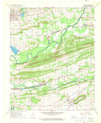 1968 Spiro1969 Print · USGSLe Flore County at the end of the 1960s shows a landscape defined by the Poteau River and the industrial activity of the regional coalfields. Researchers can trace the legacy of old Skullyville and locate rural landmarks like the French Cem and Royal Oak Ch.2 unique versions available
 - 1968 Map of Panama, 1969 Print
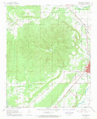
 1968 Panama1969 Print · USGSLe Flore County at the end of the 1960s shows a landscape of coal mining and river navigation along the Poteau River. Researchers can trace genealogies through Nubbin Ridge Cemetery or locate industrial sites like the many Strip Mines and the Kansas City Southern rail line.
 - 1968 Map of Poteau East, 1969 Print
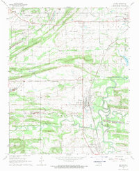
 1968 Poteau East1969 Print · USGSLe Flore County at the end of the 1960s shows a landscape where industrial transit and river geography define the local character. Genealogists and historians can trace the street layouts of Poteau or locate rural sites like McMurtrey and Double Branch Ch.3 unique versions available
 - 1968 Map of Poteau West, 1969 Print
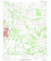
 1968 Poteau West1969 Print · USGSLe Flore County in the late 1960s is defined by the massive rise of Cavanal Mountain above a landscape of active strip mining and emerging college life. Genealogists and local historians can trace rural settlements like Witteville and Calhoun alongside the rail lines of the Kansas City Southern.3 unique versions available
End of results
Showing maps 1-8 of 8
Top cities near Poteau
- Fort Smith historical maps
- Pocola historical maps
- Heavener historical maps
- Spiro historical maps
- Panama historical maps
- Wister historical maps
See more
Frequently asked questions
- What are the different types of historical maps available for Poteau?
- What is the oldest map of Poteau?
- Where can I purchase historical maps of Poteau for my home or office?
- Where can I download high-res historical maps of Poteau?
- Are there historical topographic maps available for Poteau?
- Is there historical aerial imagery available for Poteau?
- Where are historical maps of Poteau sourced from?