1970s Maps of Poteau, Oklahoma
Explore 5 historic maps of Poteau from the 1970s. These maps offer a rare glimpse into what life looked like during the 1970s — showing old roads, neighborhoods, homes, and landmarks that have changed or disappeared over time.
Whether you're researching your family's past, planning a metal detecting trip, or studying how Poteau's landscape evolved across the 1970s, these high-resolution maps are a powerful tool for exploring the history of this region.
- Focus on a specific era: All maps on this page are from the 1970s, giving you a focused view of this time period.
- See what’s changed: Compare century-old streets, trails, and buildings to today's modern landscape using overlays and satellite layers.
- Research with precision: Use these maps for genealogy, historical research, land use analysis, or educational projects.
- View, download, or print: Maps are fully viewable online in high resolution, and can be downloaded or printed for your own records.
Start exploring Poteau's history through authentic maps from the 1970s. This is your window into the past.
Poteau, OK maps
(5)- 1977 Map of Poteau East
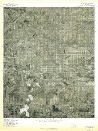 1977 Poteau East1977 Print · USGSEastern Oklahoma in the late seventies is captured in this detailed aerial perspective, showing the valley where the river meets the plains. Local historians can trace the winding Poteau River and the rural layout of Gilmore and Poteau.
 - 1977 Map of Panama
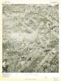
 1977 Panama1977 Print · USGSEastern Oklahoma in the late 1970s reveals a landscape defined by the winding Poteau River and established rural townships. Genealogists and local historians can trace property and settlement patterns in Panama, Shady Point, and along the slopes of Nubbin Ridge.
 - 1977 Map of Poteau West
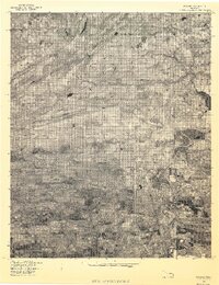
 1977 Poteau West1977 Print · USGSEastern Oklahoma's landscape is captured during the late seventies, centered on the prominent heights west of the county seat. Genealogists and local historians can trace the rural layouts of Calhoun, Witteville, and Smacker near the Poteau River.
 - 1978 Map of Fort Smith, 1979 Print
 1978 Fort Smith1979 Print · USGSThe Arkansas-Oklahoma borderlands in the late seventies show a landscape shaped by massive river reservoirs and sprawling military reservations. Trace the historic rail lines of the Missouri Pacific RR and locate regional landmarks like Fort Gibson, Tenkiller Ferry Lake, and Barling.2 unique versions available
 - 1978 Map of Fort Smith, 1979 Print
 1978 Fort Smith1979 Print · USGSThe Arkansas-Oklahoma borderlands in the late seventies show a region defined by river navigation, coal mining, and military expansion. You can trace industrial footprints like the Strip Mines and the vast Fort Chaffee Military Reservation.2 unique versions available
End of results
Showing maps 1-5 of 5
Top cities near Poteau
- Fort Smith historical maps
- Pocola historical maps
- Heavener historical maps
- Spiro historical maps
- Panama historical maps
- Wister historical maps
See more
Frequently asked questions
- What are the different types of historical maps available for Poteau?
- What is the oldest map of Poteau?
- Where can I purchase historical maps of Poteau for my home or office?
- Where can I download high-res historical maps of Poteau?
- Are there historical topographic maps available for Poteau?
- Is there historical aerial imagery available for Poteau?
- Where are historical maps of Poteau sourced from?