1970s Maps of Marshall County, Oklahoma
Explore 4 historic maps of Marshall County from the 1970s. These maps offer a rare glimpse into what life looked like during the 1970s — showing old roads, neighborhoods, homes, and landmarks that have changed or disappeared over time.
Whether you're researching your family's past, planning a metal detecting trip, or studying how Marshall County's landscape evolved across the 1970s, these high-resolution maps are a powerful tool for exploring the history of this region.
- Focus on a specific era: All maps on this page are from the 1970s, giving you a focused view of this time period.
- See what’s changed: Compare century-old streets, trails, and buildings to today's modern landscape using overlays and satellite layers.
- Research with precision: Use these maps for genealogy, historical research, land use analysis, or educational projects.
- View, download, or print: Maps are fully viewable online in high resolution, and can be downloaded or printed for your own records.
Start exploring Marshall County's history through authentic maps from the 1970s. This is your window into the past.
Marshall County, OK maps
(4)- 1976 Map of Gordonville NE, 1978 Print
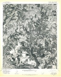 1976 Gordonville NE1978 Print · USGSMarshall County shoreline and rural farmland are captured here in the mid-seventies, showing the region's development around the reservoir. Researchers can trace the layout of small communities like Powell, Fobb, and Shay against the timbered draws of Lake Texoma.2 unique versions available
 - 1976 Map of Gordonville SE, 1979 Print
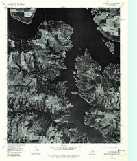 1976 Gordonville SE1979 Print · USGSGrayson County shoreline and rural settlements are captured in high detail in the mid-1970s as the reservoir shaped the local landscape. Genealogists and researchers can trace the roads and properties surrounding Gordonville, Locust, and the Cedar Mills area.
 - 1976 Map of Gordonville SW, 1979 Print
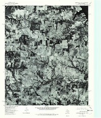 1976 Gordonville SW1979 Print · USGSGrayson County, Texas, and the Oklahoma borderlands are revealed in this mid-seventies aerial survey. Genealogists and local historians can trace the exact locations of rural homesteads near Dexter, Sandusky, and Red Branch.
 - 1976 Map of Gordonville NW, 1979 Print
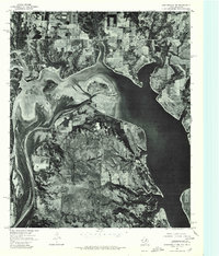 1976 Gordonville NW1979 Print · USGSThe Red River borderlands and the western reaches of Lake Texoma are captured in this late-1970s aerial survey. Trace the rural settlements of Lebanon and Enville or study the intricate sandbars where the Red River enters Lake Texoma.
End of results
Showing maps 1-4 of 4
Top cities of Marshall County
Frequently asked questions
- What are the different types of historical maps available for Marshall County?
- What is the oldest map of Marshall County?
- Where can I purchase historical maps of Marshall County for my home or office?
- Where can I download high-res historical maps of Marshall County?
- Are there historical topographic maps available for Marshall County?
- Is there historical aerial imagery available for Marshall County?
- Where are historical maps of Marshall County sourced from?