1980s Maps of Marshall County, Oklahoma
Explore 9 historic maps of Marshall County from the 1980s. These maps offer a rare glimpse into what life looked like during the 1980s — showing old roads, neighborhoods, homes, and landmarks that have changed or disappeared over time.
Whether you're researching your family's past, planning a metal detecting trip, or studying how Marshall County's landscape evolved across the 1980s, these high-resolution maps are a powerful tool for exploring the history of this region.
- Focus on a specific era: All maps on this page are from the 1980s, giving you a focused view of this time period.
- See what’s changed: Compare century-old streets, trails, and buildings to today's modern landscape using overlays and satellite layers.
- Research with precision: Use these maps for genealogy, historical research, land use analysis, or educational projects.
- View, download, or print: Maps are fully viewable online in high resolution, and can be downloaded or printed for your own records.
Start exploring Marshall County's history through authentic maps from the 1980s. This is your window into the past.
Marshall County, OK maps
(9)- 1982 Map of Dexter, 1983 Print
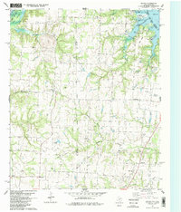 1982 Dexter1983 Print · USGSThe Red River borderlands of North Texas show a landscape of rural communities and active oil fields in the early eighties. Genealogists and local historians can locate several historic burial sites like Shiloh Cem and Allison Cem alongside the settlement at Dexter.2 unique versions available
 - 1982 Map of Platter, 1983 Print
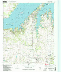
 1982 Platter1983 Print · USGSLake Texoma's eastern shore in the early eighties reveals a landscape transformed by water and recreation at the Oklahoma-Texas border. Trace the rail history of the Burlington Northern or locate family burial sites at Old Woodville Cem and Platter Cem.
 - 1982 Map of Gordonville, 1983 Print
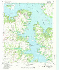 1982 Gordonville1983 Print · USGSThe Texas-Oklahoma borderlands around Lake Texoma are captured here in the early eighties, showing a landscape defined by the massive reservoir and the Red River. Researchers can locate old family cemeteries such as Mt Tabor Cem and Locust Cem alongside the early energy infrastructure of the Sandusky Oil Field.
 - 1982 Map of Pottsboro, 1983 Print
 1982 Pottsboro1983 Print · USGSThe Texas-Oklahoma borderlands around Pottsboro are shown in the early 1980s as the shoreline of Lake Texoma grew into a major recreational hub. Genealogists and local historians can trace the Old Iron Ore Grade and locate family sites near Georgetown and Willow Springs Ch.2 unique versions available
 - 1982 Map of Lebanon, 1983 Print
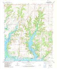
 1982 Lebanon1983 Print · USGSThe Red River border between Oklahoma and Texas is captured in the early eighties as Lake Texoma winds through the Delaware Bend. Local historians can trace family-named sites like Pleasant Oak Cem and industrial landmarks such as the Handy Oil Field.
 - 1982 Map of Kingston South, 1983 Print
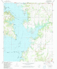
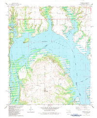
 1982 Kingston South1983 Print · USGSLake Texoma’s sprawling shoreline defines the Oklahoma-Texas border in the early eighties as recreation and industry coexist. Researchers can trace historic cemeteries like Isom Springs Cem, the Burlington Northern rail line, and local landmarks such as Enon Ch.2 unique versions available
 - 1982 Map of Shay, 1983 Print
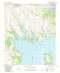
 1982 Shay1983 Print · USGSThe southern shores of Marshall County were well-established as a recreational and research hub in the early 1980s. Local researchers can trace family landmarks and community hubs like Shay Cem, the Oklahoma University Biological Station, and the crossing at Willis Bridge.
 - 1985 Map of Tishomingo, 1986 Print
 1985 Tishomingo1986 Print · USGSSouthern Oklahoma in the mid-eighties reveals a landscape shaped by significant water projects and conservation lands. Genealogists and historians can trace the footprints of communities like Wapanucka and Bromide alongside the Washita River and Lake Texoma.3 unique versions available
 - 1985 Map of Sherman, 1991 Print
 1985 Sherman1991 Print · USGSThe borderlands of North Texas and Southern Oklahoma are captured here in the mid-eighties, centered on the expansive waters of Lake Texoma. Researchers can trace the legacy of the regional rail economy through the Missouri-Kansas-Texas RR or explore the geography of Hagerman National Wildlife Refuge and Carpenters Bluff.
End of results
Showing maps 1-9 of 9
Top cities of Marshall County
Frequently asked questions
- What are the different types of historical maps available for Marshall County?
- What is the oldest map of Marshall County?
- Where can I purchase historical maps of Marshall County for my home or office?
- Where can I download high-res historical maps of Marshall County?
- Are there historical topographic maps available for Marshall County?
- Is there historical aerial imagery available for Marshall County?
- Where are historical maps of Marshall County sourced from?