1990s Maps of McClain County, Oklahoma
Explore 2 historic maps of McClain County from the 1990s. These maps offer a rare glimpse into what life looked like during the 1990s — showing old roads, neighborhoods, homes, and landmarks that have changed or disappeared over time.
Whether you're researching your family's past, planning a metal detecting trip, or studying how McClain County's landscape evolved across the 1990s, these high-resolution maps are a powerful tool for exploring the history of this region.
- Focus on a specific era: All maps on this page are from the 1990s, giving you a focused view of this time period.
- See what’s changed: Compare century-old streets, trails, and buildings to today's modern landscape using overlays and satellite layers.
- Research with precision: Use these maps for genealogy, historical research, land use analysis, or educational projects.
- View, download, or print: Maps are fully viewable online in high resolution, and can be downloaded or printed for your own records.
Start exploring McClain County's history through authentic maps from the 1990s. This is your window into the past.
McClain County, OK maps
(2)- 1990 Map of Ada
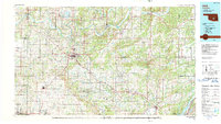 1990 Ada1990 Print · USGSOklahoma's South Central plains and woodlands appear in high detail during the late twentieth century. Genealogists and historians can trace family roots in Ada, locate local institutions like East Central State University, and explore regional hubs like Sulphur or Stonewall.
 - 1995 Map of Norman, 1999 Print
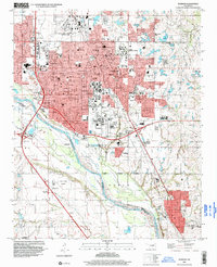 1995 Norman1999 Print · USGSNorman and the surrounding Cleveland County landscape are shown here during the mid-nineties as the city expanded around the University of Oklahoma. Researchers can trace the layout of historic campuses and local landmarks like the I O O F Cemetery, Westheimer Field, and the East Norman Oil Field.
End of results
Showing maps 1-2 of 2
Top cities of McClain County
- Newcastle historical maps
- Purcell historical maps
- Goldsby historical maps
- Wayne historical maps
- Washington historical maps
- Cole historical maps
See more
Frequently asked questions
- What are the different types of historical maps available for McClain County?
- What is the oldest map of McClain County?
- Where can I purchase historical maps of McClain County for my home or office?
- Where can I download high-res historical maps of McClain County?
- Are there historical topographic maps available for McClain County?
- Is there historical aerial imagery available for McClain County?
- Where are historical maps of McClain County sourced from?